


 68-69 / 160

69
The R.S.J.Clarke Collection of Cartography
15
th
December 2015
132
John Seller
Chart of the South-East Coast of Ireland.
545 x 245 mm.
€ 100 - 200
134
John Seller
Chart of Ireland and the Irish Sea
This chart does not appear in the 1690 edition of The English Pilot, Southern Navigation, and is first
seen in the 1701 edition. Three different plates were made, each occurring in two distinct states.
The chart was replaced in an edition of c. 1769. It also occurs on its own in the Atlas Maritimus
Novus or New Sea-Atlas, by Mount and Page, and in later editions of The English Pilot, Third Book.
It shows all Ireland and the Irish Sea, with the British coast from Cornwall to the Mull of Galloway.
The Ards peninsula and Island Magee are shown as separated from the mainland. The title (un-
framed) in the lower right corner reads
“A Chart of the Coasts of Ireland and Part of England”
.
Below this is a scale of
“English and French Leagues 20 [= 80 mm.]”
. There is one compass rose
showing north to the top and there are scales of latitude at each side. This edition from 1743. 555
x 445 mm.
€ 100 - 200
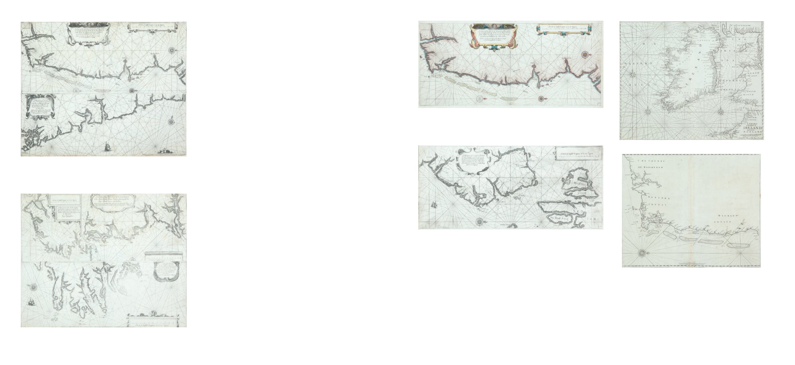
134A John Seller
Chart of the South-East Coast of Ireland
This chart appears first in Seller’s The English Pilot, Southern Navigation of 1690, and it
was unchanged in editions up to 1715. Later editions used new plates.
It shows the coast from Waterford to Dalkey and has no title. The scale in the lower centre
reads
“A Scale of English and French Leagues 20 in a Degre 5 [= 102 mm.]”.
There is one
compass rose, with 16 points, showing north to the right, and there are a scales of latitude
at top and bottom. This edition from the first English plate without title or insert. 535 x
440 mm.
€ 150 - 250
133
John Seller
Chart of the North-East Coast of Ireland.
545 x 245 mm.
€ 100 - 200
130
John Seller 1634-1697
(i) Chart of the South-East Coast of Ireland
(ii) Chart of the South Coast of Ireland
These two charts were printed from separate plates (a above b) on one page of The English Pilot,
Southern Navigation (1672), and the Atlas Maritimus. The top half can be found on a separate
sheet, but when printed together, the lower edge of the upper plate is omitted, reducing the total
height by about 15 mm. from the above figures.
(i) This shows the coast from south of Waterford to Kilkeel. It is entitled in a cartouche of strap-
work in the top-centre
“A Chart of the East side of Ireland, from Waterford to Carlingford, shewing
all the havens, Bayes, harbours, sands, depths and dangers, on the said Coast newly corrected and
Published by Iohn Seller. And are to be sold at the Signe of the Mariners Compass at the Hermitage
Stayres in Wapping.”
There are three compass roses showing north to the right, and one ship, but
no scale of latitude or longitude. The scale in the top right corner reads
“A Scale of English leagues
20 in one degree 10 [= 132 mm.].”
545 x 245 mm.
(ii) This covers the south coast of Ireland from Cape Clear to Waterford. It is entitled in a car-
touche of strap-work and fruit, in the top left corner
“A
Discription of the West side of Ireland from Cape Clere to the River of Waterford, shewing all the
Roads and Harbors on the said Coast, newly Corrected by Iohn Seller. And are to be sold at his
Shop, at the Signe of the Mariners Compass at the Hermitage stayrs in Wapping.”
Note that the title
mentions the west coast for what is really the south coast. There is one compass rose showing
north to the top, and one ship, but no scale of latitude or longitude. The scale in the lower right
corner reads
“A Scale of English Leagues 20 in one degree [10 = 132 mm.].”
545 x 215 mm.
€ 500 - 700
131
John Seller
(i) Chart of the North-West Coast of Ireland
(ii) Chart of the West Coast of Ireland
(iii) Chart of the South-West Coast of Ireland
The two upper charts are side by side with an irregular border, on one plate. The third chart, on
one plate, forms the lower half of the page in The English Pilot, Southern Navigation (1672) and
the Atlas Maritimus. As with chart I, part of both plates are omitted to allow them to be printed
on the same page.
(i) This shows the coast from the Bann mouth to Killala Bay. In the top right corner is
“A Scale of
English Leagues, 20 in one Degree 11 [= 92 mm.]”
. Below this is the title
“A Description of the North
Coast of Ireland between Banhaven and Cabo Moye, shewing all the Bayes, havens and harbors, on
the said Coast newly corrected by Iohn Seller”
. Both are in double-lined rectangular frames. There
are two half compass roses showing north to the left, but no scale of latitude or longitude. 545 x
245 mm.
(ii) This chart is separated from the above by a straight and curved border and shows the west
coast of Ireland from Killala Bay to the mouth of the
Shannon and Limerick. The title is in the top centre of the page in an oval frame and reads
“A
Chart of the West Coast of Ireland, between Cabo Moye and the River Shannon, shewing all the
Bayes, Roads, havens and harbors. Newly corrected by Iohn Seller, and are to be sold at his Shop at
the Signe of the Mariners Compass at the Hermitage stayres in Wapping”
. In the lower right corner
there is
“A Scale of English Leagues, 20 in one Degree 13 [= 110 mm.]”
. There is one half compass
rose showing north to the right, but no scale of latitude or longitude. 545 x 245 mm.
(iii) This shows the coasts of Kerry and West Cork and is entitled in the top right corner
“A Chart
of the Southwest side of Ireland, from Cape Cleare to the River Shannon, Describeing all the Bayes,
havens, Roads and Harbors one [sic] the said Coast laid downe acording to their true Courses and
distances, newly corrected and Published by Iohn Seller at the Hermitage stayres in Wapping”.
In the lower right corner there is
“A Scale of English Leagues 20 in one Degree 10 [= 132 mm.]”.
There is one compass rose showing north to the right, and one ship, but no scale of latitude or
longitude. 540 x 235 mm.
€ 500 - 800
134