


 64-65 / 160

65
www.adams.ieThe R.S.J.Clarke Collection of Cartography
15
th
December 2015
John Rocque was a Huguenot who was born in France c. 1705 and left to
settle in London c. 1734. For the next 28 years he was a prolific producer of maps, town
plans and estate surveys, and an important influence on cartographic development in the
British Isles. His most famous work was probably the large Survey of London, engraved by
Pine, which was begun in 1737 and published in 1746 in 26 sheets. As well as publishing
several other English county and city maps, he surveyed the estates of the nobility and
prepared plans and views of gardens being landscaped by Laurence “Capability” Brown.
He was appointed Topographer to the Prince of Wales.
Rocque moved to Dublin in August 1754, setting up in a shop at The Golden
Hart, Dame Street, in association with Andrew Dury (Andrews, 1967; Andrews, 1985). He
immediately began to survey Dublin, and two of his chain-men were nearly drowned while
measuring a base on the foreshore in the neighbourhood of Irishtown. In the following
year he moved to Bachelor’s Walk and published his first Irish map (of Thurles). Over
the next five years he had eleven maps printed and also produced a four-sheet map of
the harbours of Cork and Kinsale, intended for publication in January 1761, but never
finished. Over this period he also produced eight volumes of manuscript maps of the Earl
of Kildare’s estates.
Rocque trained and influenced Samual Andrews (q.v.), John Powell, and
Matthew Wren, none of whom achieved great fame, but his main successor was his
brother-in-law Bernard Scale (q.v.). Rocque had married in 1751 Mary Anne Bew (Varley,
1948), whose brother Edward Bew appears to have married Scale’s sister Mary Anne. He
returned to London in 1760 but produced only a few other maps before he died in 1762.
126
John Rocque
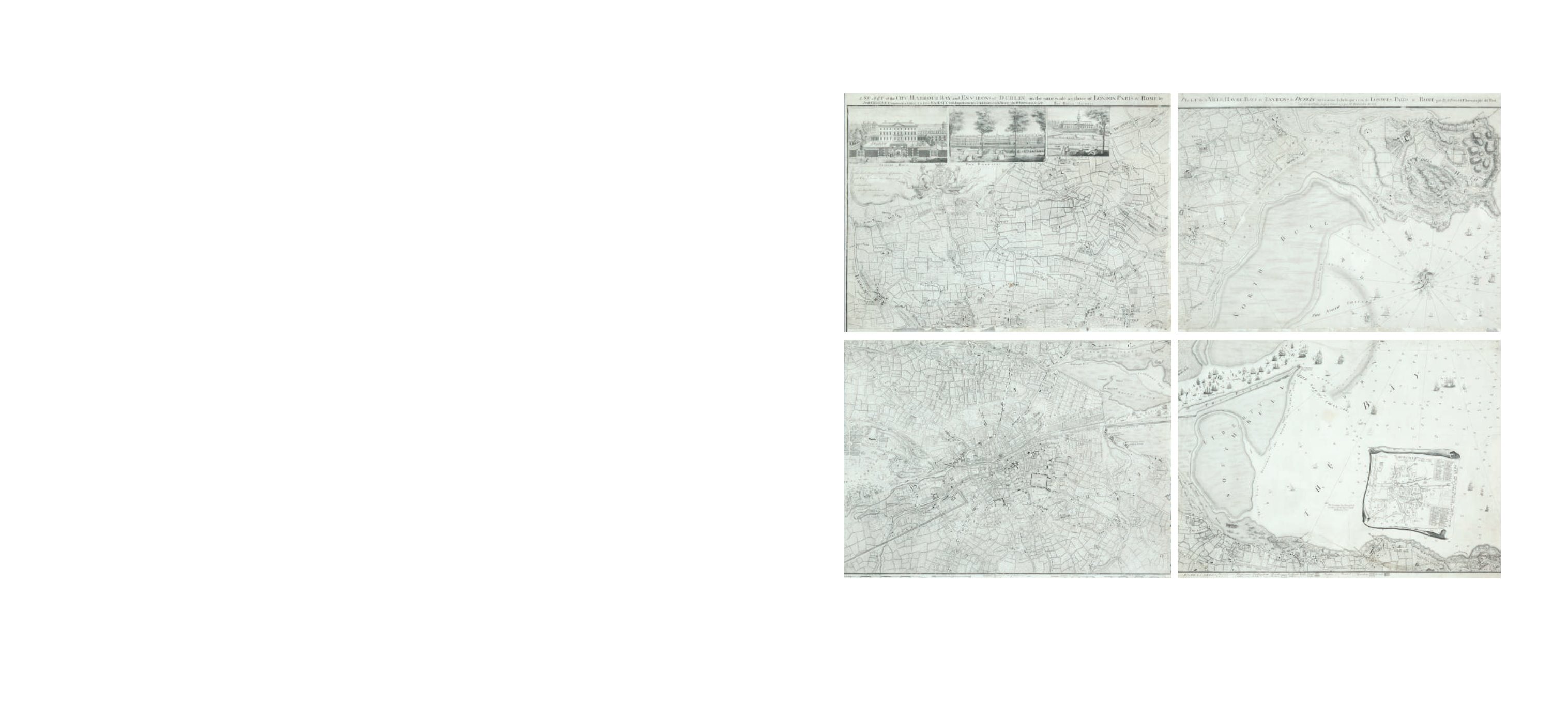
Chart of Dublin Bay and Plan of Dublin and Environs
This is on four sheets, the bottom left sheet of which can be regarded as a town-plan of
Dublin and the remainder as a map of the surroundings and a chart of Dublin Bay. The
town-plan is a later state of No. 2 described in the Introduction, with the addition of river
depths and the outer administrative boundary of the city.
It shows the coast from Scotchman’s Bay, Dalkey, northwards to include all of Howth Head,
and inland to the centre of Phoenix Park and Finglas. The title is printed above the top of
the two northern sheets and reads
“A Survey of the City Harbour Bay and Environs of Dublin on the same scale as those of Lon-
don Paris & Rome By John Rocque Chorographer to his Royal Highness the Prince of Wales.
Plan de la Ville, Havre, Baye & Environs de Dublin sur la meme Echelle que ceux de Londres,
Paris & Rome par Jean Rocque chorographer du Roi avec des additions jusq a l’année 1773
par Mr Bernard Scalé.”
In the top left, in an irregular frame with the royal arms, is the dedication
“To His Royal
Highness Prince Edward This Plan is most humbly inscribed by His Most Obedient Humble
Servt. John Rocque.”
Below the left half of the frame are four scales:
“A Scale of an Irish
Mile 320 Perches [= 168 mm.] A Scale of Yards 1000 [= 83 mm.] Echelle de Toises 500 [= 93
mm.] A Scale of an English Mile 320 Perches [= 132 mm.]”.
Alongside the scales is
“Published
according to Act of Parliament” and “J.J. Perret Sculpt.”
Below the right half of the frame is
an “Explanation” of the many symbols of boundaries and types of land use on the map.
The bay has an indication of sand-banks and coastline with many soundings and 75 ships
extending up the river Liffey. There is a decorative compass indicator of fish, nets and
cornucopia showing true and magnetic north to the top left.
There are three insets in the top left corner:
1. “Kildare House” (120 x 210 mm.) showing the house and frontage on to Kildare Street,
with various types of carriages arriving.
2. “The Barracks” (120 x 208 mm.) with ladies and gentlemen strolling in front.
3. “The Royal Hospital” (105 x 133 mm.) at Kilmainham, viewed from across the river.
There is also an inset in the bay (195 x 197 mm.), depicted as if on a sheet, showing
“Dublin
Anno 1610 Dublin comme il etait en 1610”
. The plan is flanked by two notes
“The Figures
of the surroundings are Dotted thus . to distinguish them from those of the References. this
Plan is Copyed from that Taken in 1610 and the Spelling the Same as at that Time.”
There
are 69 numbers and a key for streets and buildings. Four sheets when joined. 1,395 x
1,010 mm. (4) For a full description see Abl Printed maps of Dublin R2.1-4
€ 5,000 - 7,000
John Rocque (1705-1762)