


 66-67 / 160

67
The R.S.J.Clarke Collection of Cartography
15
th
December 2015
John Seller was born between 1627 and 1630, the son of Henry Seller, a cordwainer of Wapping (Verner,
1973; 1978; Tyacke, 1978). He was apprenticed in the Merchant Taylor’s Company to Edward Lowe, instru-
ment maker, on 4th September 1644 and became free on 25th October 1654. His first publication was T.
Gadbury’s The Young Seaman’s Guide (1659), at which time his address was “the Mariner’s Compass and
Hour Glass at the Hermitage stairs in Wapping”. He remained there all his life, being an instrument maker,
expert on navigation and (less successfully) a publisher. However he had other selling outlets in the City of
London, such as Pope’s Head Alley, the West End of the Royal Exchange, and the West End of St. Paul’s. He
was a Baptist and in 1662 was charged with High Treason. He was convicted but, perhaps with the help of
the Duke of York, was not executed and was released in the following year. He married c. 1666 Elizabeth ....
and had 2 sons and 2 daughters.
John Seller’s first map (of New Jersey) was published in 1664 and he produced the very success-
ful Praxis Nautica or Practical Navigation in 1669. The first edition of The English Pilot, Northern Navigation
probably came out in 1668 (Verner, 1978), though it is usually dated to 1671, followed by the Southern Navi-
gation in 1672, with 49 charts altogether. There was also A Description of the Sands ....
South Foreland
to Orfordness, with 1 map (1671). The English Pilot, Southern Navigation contains 3 pages of Irish charts
covering the whole Irish coast in six sections (vid. inf. I - III). Seller’s plates were mostly old worn Dutch
plates which had been abandoned by their original owners : e.g. Jansson’s version of Blaeu’s Het Licht der
Zeevaert (1620) and Van Loon’s Zee Atlas (1650). He had obtained 63 copper plates by 1669, probably by
visiting Amsterdam, and was already making the Pilot at this time. In spite of his lack of originality and the
inaccuracies of the charts, he was appointed Hydrographer to Charles II on 24th March 1771, and later to
James II. The upper plate of chart II is found printed alone on a page without the title “Regis Hydrographus”,
suggesting that it was first printed before March 1771.
In 1672, as well as The Southern Navigation, John Seller published The Coasting Pilot (without
Irish charts) and a second edition of the Description of the Sands. In 1675 he published the Atlas Maritimus
with about 30 charts, including in some editions one of the south-eastern 3/4 of Ireland (IV). Some editions
contain instead, the three other Irish charts, but many have no Irish chart. Washington has four copies of
the Atlas Maritimus, dated in the catalogues between 1670 and 1672, as well as one of 1675, but Verner
states firmly that all are post-1675. All these books, from 1668 to 1675, were
printed by John Darby.
John Seller’s sales were poor and he sought to evade bankruptcy
by combining in 1677 with John Thornton, William Fisher, James Atkinson and
John Colson. The combine issued The English Pilot, Mediterranean Sea, and
re-issued The Coasting Pilot, Atlas Maritimus and Description of the Sands. It
was disbanded in 1679 and the title to The English Pilot and The Atlas Maritimus
were transferred to William Fisher. Both Fisher and Thornton appear to have
retained the bulk of the stock, though Seller was left with some plates and print-
ed sheets. There is no Irish chart in the small Atlas Maritimus of 1682.
From 1690 The English Pilot was re-issued with the Southern
Navigation as Part I (1690, 1701 .... and 1792) for 22 editions, and the Northern
Navigation as Part II (1716, 1723, .... and 1792) for 10 editions. There were also
volumes covering the Mediterranean Sea (expanded), the Oriental Navigation
(with an Irish chart), the West India Navigation and the West Coast of Africa,
comprising books II to V. The English Pilot, Oriental Navigation or Book III may
be regarded as totally John Thornton’s publication and is described under him.
The early editions (1703, 1711 and 1716) have Thornton’s charts II or III. The
editions from 1734 onwards use the Seller/Mount and Page charts X and XI.
In the new editions of The English Pilot, Southern Navigation
Seller’s original 3 pages of charts were replaced by 7 new charts, and these
continued to be used, with minor variations, for all later editions. The chart
of all Ireland is not actually in the 1690 edition but is included from 1701
onwards. Their authorship is not clear, but was presumably John Thornton or
William Fisher since Seller was no longer involved. On the other hand his name
still appears on the title page and he did not die until 1697, so that it seems
reasonable to use his name for the series. The chart of Galway Bay and the
Shannon (IX) cannot have been issued until after 1693, which means either that
the whole volume (known only in a B.L. copy) cannot be as early as 1690, or that
this particular chart was added after the volume was printed. Greenvile Collins’
chart of Cork Harbour (VII) occurs in The English Pilot from 1690 onward, to be replaced by
the second version of this (IX) in 1745 and Lindsay’s chart (I) in 1759.
John Seller died “of dropsy” in May 1697 and was buried at St. John’s, Wap-
ping. His widow continued the business and died in December 1711, being buried with
her husband. The eldest son John, was born c. 1667 and was apprenticed on 21st August
1681 to his father in the Merchant Taylor’s Company for 7 years. On 26th March 1686
however, he was admitted to the freedom of the Company of Stationers by patrimony.
He opened a shop in that year at “The Star next the Mercer’s Chapel in Cheapside” and
in 1687-89 at “The West End of St. Paul’s Churchyard”. On 16th April 1688 he married
Elizabeth Perwick of Hackney and had 1 surving daughter but no sons. After 1698 he gave
up business as a stationer and died in October 1698, being buried with his father.
After the death of John Seller, senior, his younger son Jeremiah and his widow
took over the business of instrument seller and publisher at the old address, though with
little stock. He published Practical Navigation in 1699, and in 1701 with Charles Price pro-
duced a new volume of The English Pilot, Oriental Navigation. He too became bankrupt in
1705 and lost most of his stock and instruments, the plates and map sheets being bought
by Richard Mount. He married Ann ...., had 4 children, and was still alive in the 1720’s.
Richard Mount was apprenticed to the firm in 1669 and in 1682 he married
unto the Fisher family, gradually taking over the business. Thomas Page was a relative of
Richard Mount and was associated from 1700. Their descendants continued to bring out
The English Pilot, Southern Navigation throughout the 18th century, the only major variant
being the Dublin edition “Printed by and for Geo. Grierson at the Two Bibles in Essex
Street MDCCXXX.”
Ralph William Seale was a map engraver who flourished in London from c. 1732 to
1775. His first known production was a map of Dorsetshire to accompany A Survey of Dorsetshire,
published by J. Wilcox in 1732 (Chubb, 1927). He assisted W.H. Toms to engrave Popple’s Map of the
British Empire in America in 1732 and the maps in Geographica Antiqua, first published in 1742, and
also engraved plans of Aldgate and Aldersgate Wards in 1739.
Seale engraved the maps for Tindal’s Continuation of Rapin’s History of England, pub-
lished in 1744-47. Rapin de Thoyras’s History of England covered the period up to the Revolution of
1688. Nicholas Tindal, M.A., Rector of Alderstoke in Hampshire and Chaplain to the Royal Hospital
at Grenwich, continued the history from the Revolution to the accession of George II (1727). This
edition of 4 quarto volumes (the last split in two) has portraits, maps and town-plans scattered
throughout as well as at the end of the volume. There are three Irish map pages :-
1.
Map of Ireland (495 x 395 mm.)
2.
Chart of Ireland and the Irish Sea (“St. George’s Channel”) (475 x 375 mm.).
This is described below.
3.
Town Plans of Ireland (405 x 495 mm.).There are four columns with four plans in each:-
Drogheda Londonderry KinsaileCharlemont Dublin Coleraine Corke Harbour Gallway
Kilkenny Carrickfergus Corke City Athlone Waterford Belfast Duncannon Limerick
There were later editions in 1751 (similar to that described above) as well as the editions of 1757
and 1789 which have no Irish maps or charts.
Seale later produced plans for Stow’s Surveys of the Cities of London and Westminster
in 1754 and 1755; maps of the rivers Calder, Wear and Wey; a large map of England and Ireland in 9
sheets, c. 1770; maps and a chart for the London Magazine and Universal Magazine, 1747-63; a map
of the War in North America, 1757; and many others.
127
Ralph William Seale 1732-1775
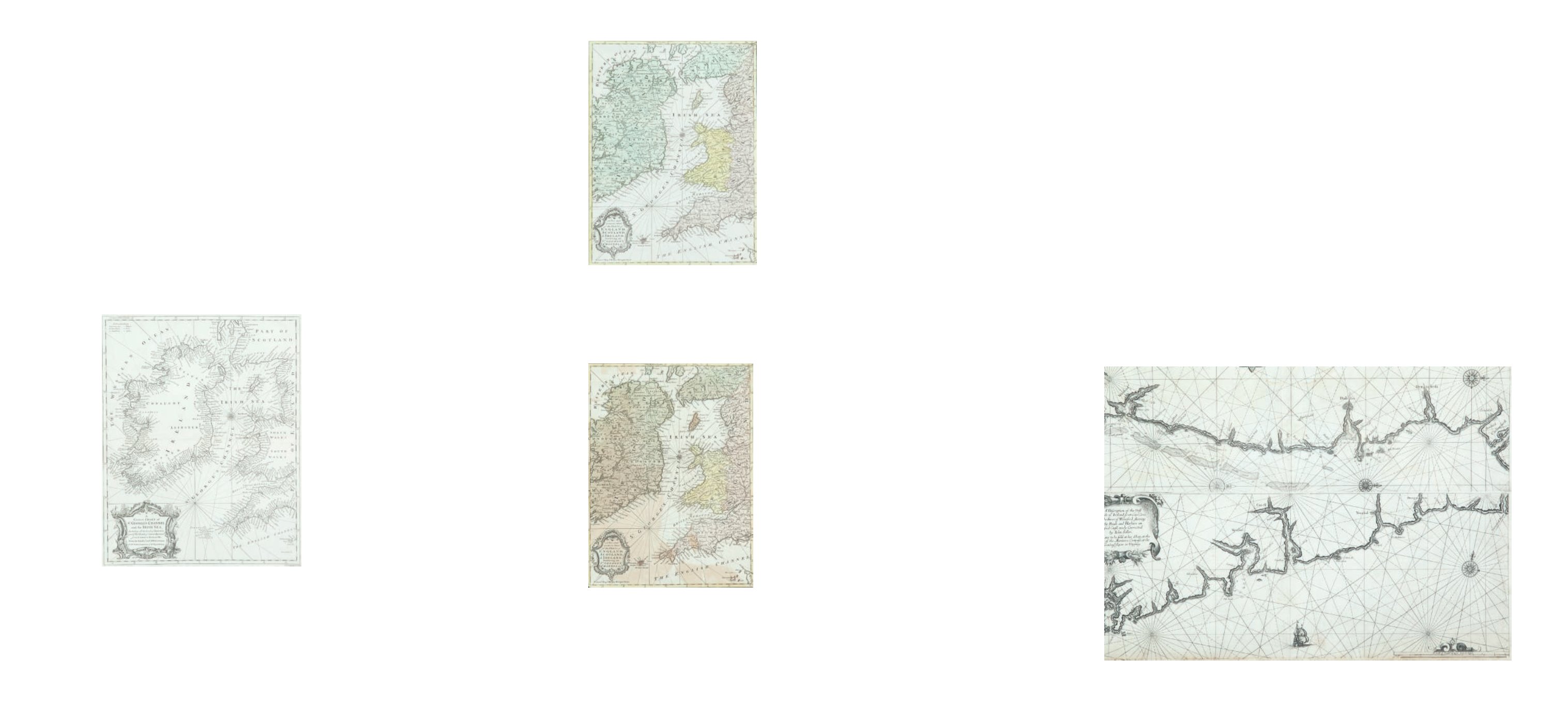
Chart of Ireland and the Irish Sea
This is found with other maps and charts at the end of Volume 3 or 4 of
Tindal’s Continuation of Rapin’s History of England, first published between 1744 and 1747, and in
the second editon of 1751.
The title in the lower left corner is in an ornate scalloped frame and reads
“A Correct Chart of St.
George’s Channel and the Irish Sea, Including all the Coast of Ireland and ye West Coast of Great Brit-
ain from Cantire to Portland Isle: From the latest & best Observations. For Mr. Tindal’s Continuation
of Mr. Rapin’s History”.
375 x 475 mm.
€ 100 - 150
128
Ralph William Seale 1732-
1775
The Irish Sea
This occurs in The Universal Maga-
zine of 1757 (Vol. 21, opposite p. 49.)
The title in the lower left corner in
an ornate scalloped frame, reads
“A New and Accurate Map of the
Parts of England, Scotland & Ireland,
Bordering on St. George`s Channel,
&c.”
Below the frame is
“Univers.
Mag. J. Hinton, Newgate Street”
and
below the right corner of the frame
is
“R.W. Seale del. et sculp.”
265 x 365 mm.
€ 100 - 200
129
Ralph William Seale 1732-
1775 II
The Irish Sea
This occurs in The Universal Magazine
of 1757 (Vol. 21, opposite p. 49.)
It shows a similar area to the previous
chart except that it omits the west
coast of Ireland. There are fewer
markings round the coast, but there
are again the rhumb lines, without
soundings.
The title in the lower left corner in
an ornate scalloped frame, reads
“A
New and Accurate Map of the Parts of
England, Scotland & Ireland, Bordering
on St. George`s Channel, &c.”
Below
the frame is
“Univers. Mag. J. Hinton,
Newgate Street”
and below the right
corner of the frame is
“R.W. Seale del.
et sculp.”
There is no scale of length,
but latitude and longitude west from
London are marked along all four
sides, and there is one compass rose.
265 x 365 mm.
€ 100 - 200
Ralph William Seale 1732-1775
John Seller 1634-1697