


 72-73 / 160

73
www.adams.ie152
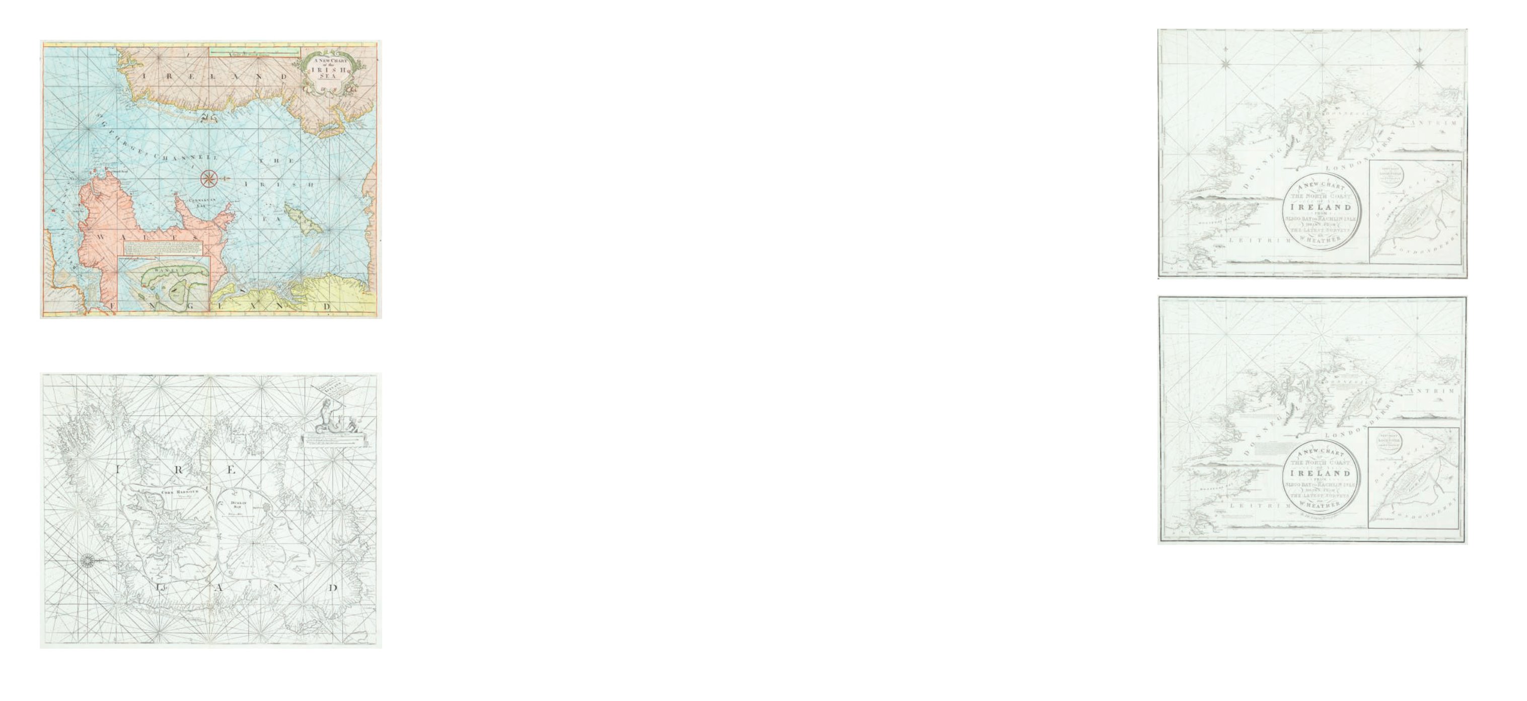
William Heather
Chart of the North Coast of Ireland
The title is in a circular frame in the centre and reads
“A New Chart Of The North Coast
of Ireland From Sligo Bay to Rachlin Isle Drawn From The Latest Surveys for W. Heather.
1807”.
Below the title is
“J. Stephenson Engraver”
.
Below the frame is the imprint
“London. Published as the Act directs, January 1st 1807, by
William Heather, at the Navigation Warehouse, No. 157 Leadenhall Street”.
This is part of a series of three charts covering the north, west and south coast of Ireland,
first produced in 1807. It overlaps chart V to include Sligo town.
It shows the coast from Ballycastle and Rathlin Island, county Antrim, to Achris Head,
county Sligo. There are scattered coastal profiles, notes on the sea bottom, numerous
soundings and tide and current marks. There are also two compass roses showing north
to the top and scales of latitude and longitude west from Greenwich, on all four sides.
Magnetic variation is dated 1807.
In the lower right corner is an inset (265 x 230 mm.) entitled
“A New Chart of Loch Foyle,
being the Entrance to Londonderry”
with a
“Scale of Miles 6 [= 70 mm.]”
and one compass
rose showing north to the top.
780 x 645 mm.
€ 200 - 300
153
William Heather
Chart of the North Coast of Ireland
The title is in a circular frame in the centre and reads
“A New Chart Of The North Coast
of Ireland From Sligo Bay to Rachlin Isle Drawn From The Latest Surveys for W. Heather.
1807”.
Below the title is
“J. Stephenson Engraver”.
780 x 645 mm.
€ 200 - 300
151 William Heather
Chart of the St. George’s and English Channels
The dedication is unframed in the top centre and reads
“To the Right Honorable the
Master, Wardens and Elder Brethren of the Trinity House this Chart of the English Channel Is
most humbly dedicated by their obedient Servant William Heather.”
This was first produced as a separate chart in 1794 on three sheets which may be joined
together. A new edition was printed in 1805.
It shows the Irish coast from county Clare to Wexford, the British coast from Barmouth
to Yarmouth and Europe from Britany to Haarlem in the Netherlands. There are detailed
soundings round the coast and in the open sea, as well as tide and current marks and
notes on the sea bottom. Below the frame is the imprint
“Published as the Act directs, July
12th 1794 by W. Heather, at the Navigation Warehouse, No. 157 Leadenhall Street, London.”
The navigational route through the English Channel is marked by a hand and two ships on
the left sheet and two further ships on the middle sheet. There are scales of latitude and
longitude east and west from London on all four sides, as well as three coastal profiles
in the top centre. Magnetic variation on the left sheet is dated 1794 and there are four
compass arrows showing north to the top as well as four ships.
There are six insets in the right sheet, each with one compass arrow showing north to the
top:
1. (142 x 345 mm.) entitled
“Portsmouth”
, with a “
Scale of Miles 5 [= 30 mm.]”
.
2. (100 x 120 mm.) entitled
“Sketch of the Situation of The Owner’s Light by order of the
Trinity House, 1794.”
3. (235 x 125 mm.) entitled
“Dartmouth”
, with a
“Scale of half a Mile 1/2 [= 45 mm.]”.
4. (175 x 175 mm.) entitled
“Falmouth”
, with a scale of
“One Mile [= 30 mm.]”.
5. (175 x 165 mm.) entitled
“Plymouth”
, with a scale of
“One Mile [= 30 mm.]”.
6. (315 x 192 mm.) entitled
“Downs and Margate”
, with a
“Scale of Miles 3 [= 41 mm]”.
1,890 x 775 mm.
€ 300 - 500
142
John Thornton (1670-1715)
A Chart of the Irish Sea
Originally published in his Atlas Maritimus (1685)
This is the third state from the English Pilot Southern Navigation (1760). 525 x 430
€ 250 - 350
143
Samuel Thornton (1670-1715)
A Chart of the Irish Coast with Insets of Dublin and Kinsale
This is John Thornton’s 1703 chart reprinted by his son in the Coasting Pilot.
€ 300 - 400
152