


 62-63 / 160

63
www.adams.ieThe R.S.J.Clarke Collection of Cartography
15
th
December 2015
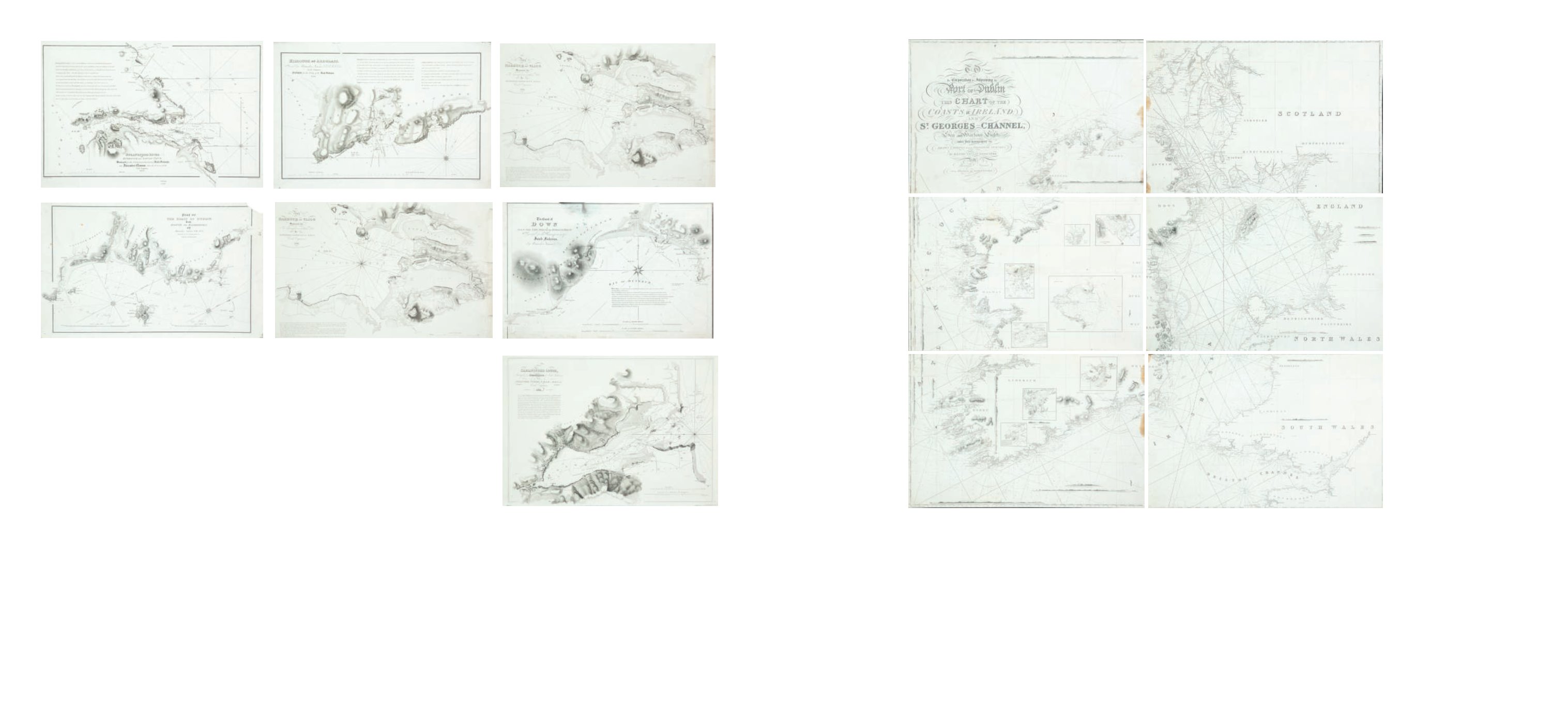
125
Alexander Nimmo
Ireland and the Irish Sea
It shows the whole of Ireland and the retated coast of Scotland, England and Wales. The title (covering half of the top left sheet) reads
“To the Corporation for Improving the Port of
Dublin this Chart of the Coasts of Ireland and St George`s Channel, exhibiting the Sea and Harbour Lights under their management, drawn chiefly from original Serveys, is respectively
dedicated by Alexander Nimmo, Civil Engineer and Hydrographer. Engraved by Josiah Neele, 352 Strand, London.”
There are five insets on Sheet 3 (Connaught): Bay of Moy, Carlingford Bar, Roundstone Bay, Dublin Bay and Galway Bay; and three on Sheet 5 (Cork): Waterford, Cork and Valentia. Six
sheets when joined. 1,760 x 1,740 mm.
€ 600 - 1,000
Alexander Nimmo, F.R.S.E., M.R.I.A. was
a civil engineer and surveyor who produced many
charts of Irish harbours for Irish Fisheries, as well as
a large chart covering the coasts of the whole island
His first chart was of Iveragh, county Kerry, in 1811,
followed by Strangford River, Killough and Ardglass,
Lee Stone to St John`s Point, Carlingford Lough and
the Harbour of Sligo in 1821, and the coast of Dublin
in 1822. Valencia was published in 1832 and Youghall
in 1835. About 1840 he produced his large chart in six
sheets covering the whole of Ireland.
124
Alexander Nimmo
A Collection, including:
(i) Entrance to Strangford Lough
It shows the coast from Ballyhornan to Chapel Island and Ballyquinton Point to Ballyhenry. The title reads
“Strangford River or the Entrance
to Lough Cone, Surveyed for the Commissioners for Irish Fisheries by Alexander Nimmo, F.R.S.E., M.R.I.A., &c, &c., Civil Engineer, 1821.”
Below the frame is
“W.R. Graant del.” and “Neele & Sons at 352 Strand”
.
Copies: R.S.J.C. 440 x 320 mm.
(ii) Killough and Ardglass
It shows the coast of St John`s Point, Killough and Ardglass. The title reads
“Killough and Ardglass, surveyed by Alexander Nimmo, F.R.S.E.,
M.R.I.A., &c., Civil Engineer. Published for the use of the Irish Fisheries, 1821.”
Below the frame is
“Neele & Sons, 352 Strand.”
Copies: R.S.J.C. 465 x 285 mm.
(iii) Newcastle and Dundrum
It shows the coast from Lee Stone Point to St. John`s Point with much of the Mourne Mountains. The title reads
“The Coast of Down from
the Lee Stone to St John`s Point, Surveyed for the Commissioners of Irish Fisheries by Alexander Nimmo, C.E. &c.
Below the frame is
“Neele & Sons, 352 Strand.”
Undated, but of c. 1821.
Copies: R.S.J.C. 460 x 300 mm.
(iv) Carlingford Lough
It shows Carlingford Lough and surrounding coast north and south. The Title reads
“Carlingford Lough Surveyed for the Commissioners of
Irish Fisheries by Alexander Nimmo, F.R.S.E., M.R.I.A., Civil Engineer, 1821.”
Below the frame is
“Wilson Lowry, Sculpt.”
Copies: R.S.J.C. 475 x 340 mm.
(v) The Harbour of Sligo
It shows the coast from Rinoran Point to Carrigfadd and the estuary up to Sligo city. The title reads
“The Bay and Harbour of Sligo Surveyed
for the Commissioners of that Port By Alexander Nimmo, F.R.S.E., M.R.I.A., Civil Engineer, 1821. Published for the use of the Irish Fisheries.”
Copies: R.S.J.C. 500 x 340 mm.
(vi) Dublin Bay
It shows the north part of Dublin Bay with details of Lambay Island. The title reads
“Part of the Coast of Dublin from Howth to Balbriggen by
Alexander Nimmo, C.E., 1822. Surveyed for the Commissioners of Irish Fisheries.”
Below the frame is
“Neele & Sons, No. 352 Strand.”
500 x 305 mm.
€ 1400 - 1800