


 58-59 / 160

59
www.adams.ieThe R.S.J.Clarke Collection of Cartography
15
th
December 2015
119
Murdoch Mackenzie
Chart of East Ireland and the Irish Sea
This is the 6th chart in Vol. II of A Maritime Survey of Ireland, published in London in
1776. It is printed on five sheets joined together and has “Chart VI” in the top right
corner.
It shows the east coast of Ireland from Greenore, county Wexford, to
Coleraine, County Londonderry, and the west coast of Great Britain from mid-Wales
to the Mull of Kintyre. The title is in a rococo frame in the left centre, with ships at the
quayside, a globe and books, and the symbols of England, Scotland, Ireland and the
Isle of Man (rose, thistle, harp and three legs).
It reads
“A General Chart of the Irish Channel by M. Mackenzie senr.”. Below the title
cartouche is (unframed) “A Scale of 10 Leagues, 20 to a Degree of the Meridian 10 [= 161
mm.]”.
Between the two is
“Engrav’d by G Terry, 62, Paternoster Row.” and below the chart
frame is “Published as the Act directs Novr. 26th 1775”.
chart VI
There are three compass roses showing north to the top, with magnetic variation
dated 1760, and scales of latitude on each side. 955 x 1,165 mm.
€ 200 - 300
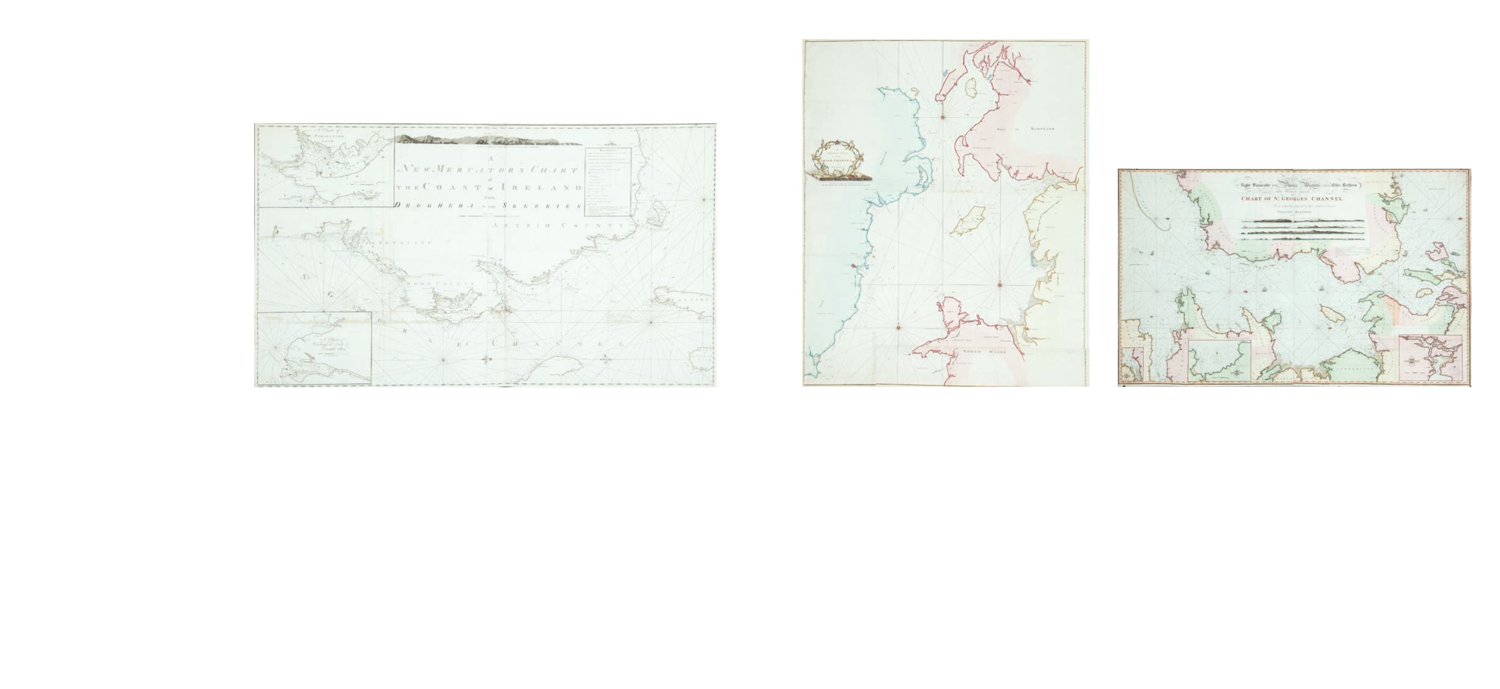
120
William Heather
A Chart of St. George’s Channel
Dedicated to the Officers of Trinity House.
790 x 1,230.
€ 300 - 500
Murdoch Mackenzie, senior, was born in 1712, the grandson of a former bishop of the Orkneys.
His aptitude for mathematics brought him into contact with Colin Maclaurin, Professor of Mathematics at Ed-
inburgh and, when in 1739 the Earl of Morton wanted a sur vey of the Orkneys carried out, Mackenzie’s name
was suggested. Maclaurin also drew up a memorial of observations, measurements and instruments which he
felt were needed for the survey. This was to be the most accurate and detailed charting yet carried out in the
British Isles and the Navy Board gave support by lending Mackenzie
a theodolite. plane-table and chain.
Mackenzie started work about 1746 and having erected
beacons on the hills, took as a base-line a distance of 3 3/4 miles in
the frozen loch of Stenhouse. From this he triangulated the whole
group of islands and related them to the mainland. He published
“The State of the Tides in Orkney” (Phil. Trans. Roy. Soc.) in 1749 and
his atlas Orcades or a Geographic and Hydrographic Survey of the
Orkney and Lewis Islands in 1750. The latter describes his methods
of surveying in detail and contains 8 charts of the islands. There
were further editions in 1767, 1776 and 1791, in spite of an attack
by Dr. Anderson in 1785 suggesting that no survey had been carried
out and that the whole had been meerly sketched.
Mackenzie, however had the confidence of the Admi-
ralty and was appointed as their hydro-surveyor, being now asked
to survey the whole west coast of Britain and all Ireland. Eastern
Scotland and the Isles were covered in 1751-57 with the Antrim
and Down coast of Ireland in 1758-59. Mackenzie then worked
clockwise round Ireland until 1768, covering also Cumberland and
Lancashire in 1761 and 1762. Finally he reached Wales in 1769-70
and stopped at Pembroke. He published A Treatise on Maritim
Surveying in 1774 describing his methods in general and was made
a Fellow of the Royal Society in that year. He published in two major
volumes in 1776, A Maritim Survey of Ireland and the West Coast
of Great Britain. Volume I contained 28 charts covering Ireland,
and Volume II had 31 charts covering the west coast of Britain. The
charts in Volume I are divided into three general charts covering
the south, west, and north coasts of Ireland (I, VII and XX), as well
as twenty-five detailed charts of the whole coast and tidal estuaries.
Volume II, chart VI, covers the east coast of Ireland, the Irish Sea and the whole of the opposite British coast. All
these charts are described in detail below, but not the other British charts. All of them, being too large to be
printed on one sheet, are made up of two or mor e sheets joined together.
The engraving of Volume I was carried out by Garnet Terry of 62 Paternoster Row, London (13
pages), Thomas Bowen of Fleet Street, London (10 pages) and Thomas Conder of London (1 page). There are
also 8 unsigned pages. There are distinguishing features about each engraver’s work. e.g. Terry’s capital letters
in the titles are not solid and have internal decorations, and his compass rose usually has 32 rather than 16
points. The charts are all dated and i t appears that all engravers were working at the same time, the dates of
publication being between June 1775 and January 1776. The engraving of Volume II extended to March 1776
and as well as the same engravers included also Thomas Kitchin and Francis Vivares.
Accompanying the chart volumes, there were also two volumes of Nautical Descriptions which are
referred to page by page, on each of the detailed charts. The first volume is entitled Nautical Descriptions of
the Coasts of Ireland adapted to the several Charts in the Maritim Survey of Ireland. Containing a particular Ac-
count of the Tides, Rocks, Shoals, Channels, Anchoring-Places and Harbours along these Coasts; with suitable
Sailing Dircetions interspersed. To which is prefixed The Principal Observations and Measurements, on which
the Survey was grounded. By Murdoch Mackenzie, Sen., London. Printed for the Author, and sold (together
with the Charts) by Mount and Page, on Tower Hill; Sayer and Bennett, in Flee t Street: Jefferies and Faden, in
the Strand, near Charing Cross; and Dury, in Duke’s Court, Leicester-Fields. MDCCLXXVI. The volume measures
295 x 195 mm. and contains 3 introductory pages and 82 pages of text.
Murdoch Mackenzie, senior, died on 16th October 1797 and was buried at Minehead, Somerset.
The work was continued by his nephew Lieut. Murdoch Mackenzie, junior, who was born in 1743 and also be-
came Hydrographer to the Admiralty. He produced a chart of the Bristol Channel in 1771 and continued round
the south coast of England until 1810, improving on his uncle’s methods, particularly as regards soundings and
mapping of sand banks. Murdoch Mackenzie, junior, died in 1829.
118
Murdoch Mackenzie.
Chart of the North East Coast of Ireland
This chart was printed in a left and right half, which are separate in the B.L. version but can
be mounted together. It has “Pl. 2” printed above the top right and left corners.
It is one of the six charts published after Murdoch Mackenzie`s death but based on his
surveys (only acknowledged in the second state).
The title in the top centre, unframed, reads
“A New Mercator`s Chart of the Coast of Ireland from Drogheda to the Skerries. The imprint
below the frame reads “London, Published as the Act Directs, Jany. 1st 1800, by D. & E. Steel
at the Navigation Warehouse, Little Tower Hill.”
North is to the right and there are scales of latitude and longitude west from London along
the four borders, There is a key to “References” or symbols framed to the left of the title
and one coastal profile in the top centre. There are two insets:-
1. “A Chart of Strangford Loch”., with a “Scale of four English Miles 4” and showing north
to the bottom right.
2. “A Chart of Carlingford Loch and Dundalk Bay.”, with a “Scale of four English Miles 4”.
North is unmarked but at the bottom. 1,310 x 765mm.
€ 300 - 500
Murdoch Mackenzie