


 60-61 / 160

61
The R.S.J.Clarke Collection of Cartography
15
th
December 2015
William Morris, surveyor and hydrographer, was the son of the more famous
Lewis Morris who, though he published no charts of Irish waters, made an outstanding
contribution to Welsh marine surveying and hydrography generally. Lewis was born in
Anglesey in 1701 (Robinson, 1962) and trained as a land surveyor from 1724 with Owen
Meyrick of Bodorgan, making estate surveys in Anglesey and acquiring the basic skills of
coastal surveying. In 1729 he was appointed customs officer to Beaumaris and Holyhead
and was able to indulge his intere st in philology, folklore and local history. However, his
main concern from 1737 was in surveying the Welsh coast, a project which had encour-
agement but little financial help from the Government. The results were published in his
Plans of Harbours, Bars, Bays and Roads in St. George’s Channel in 1748, which however
contains no Irish charts. He also published in the same year a chart of St. George’s Chan-
nel which contains a bare outline of the Irish coast along one edge. Lewis was appointed
superintendant of crown lands and mines in Wales in 1750, retired to Penbryn in 1761 and
died on 11 April 1865 (see D.N.B. xxxix, 101).
123
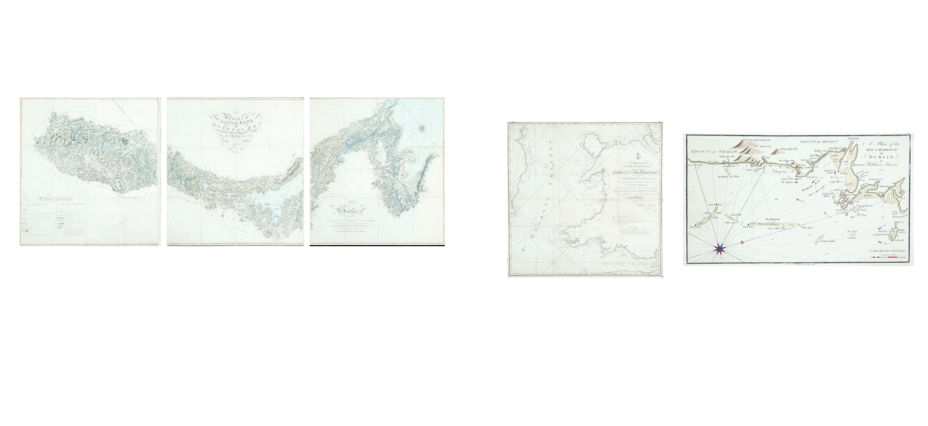
William Morris
Chart of Dublin Bay
This is the last chart in William Morris’s Plans of the Principal Harbours, Bays & Roads in St.
George’s and the Bristol Channels, which was first published in 1748 by his father, though
this chart only appeared in this edition of 1801.
It shows the Irish coast from Five Mile Point, County Wicklow, to Lambay Island. The title
is unframed in the top right corner and reads “A Plan of the Bay and Harbour of Dublin by
William Morris” and an imprint below the lower border reads “Publish’d by W. Morris 25th
Novr. 1800. Simpkins fe.”.
In the lower right corner is “A Scale of Miles 4 [= 50 mm.]”. There are soundings along the
whole coast and round the sandbanks, as well as signs for the currents and lighthouses.
One compass rose shows north to the top right. 320 x 187 mm.
€ 150 - 250
122
William Morris
Chart of St. George’s Channel
This is a loose chart, considerably modified from Lewis Morris’s chart of 1748 covering the
same area, which was published in 1800.
It shows the Irish coast from Carnsore Point, county Wexford, to Lambay Island, county
Dublin, as well as the British coast from north Somerset and Cardiff to Formby, Lancashire.
The title in the centre right, unframed, reads “To the Right Honourable the Lords Com-
missioners for executing the Office of Lord High Admiral of Great Britain, Ireland, &c. This
Chart of St. George’s Channel &c. Surveyed under their Lordships’ direction by the late
Lewis Morris Esqr. which is now extended by an Actual Survey (the whole Corrected &
much Improved) from Liverpool to Cardiff in the Bristol Channel; is by Permission most
respectfully dedicated by their Lordships’ obedient humble servant William Morris”.
Below the lower margin is “Published 25th Novr. 1800 by Willm. Morris. Engraved by Wm.
Simpkins, Clements Inn”. Below this is an explanation of symbols and below it, unframed,
is “A Scale of Leagues 10 [= 147 mm.]”. There is one compass rose showing north to the
top and there are scales of latitude and longitude (W. from London) along all four borders.
780 x 885mm.
€ 300 - 500
George Montgomery is known only for his chart of Lough Erne, published in 1818. He is
described as living in Lifford, county Donegal and the chart was published by Edward Duffy
of Enniskillen
121
George Montgomery
Chart of Lough Erne and Donegal Bay
This is a navigational chart in three separate sheets mounted on cloth, The title is in the
upper centre, unframed, and reads
“A Chart of Lough Erne and Donegal Bay, in the Counties of Cavan, Fermanagh and Donegal,
with a Map of the adjacent country, delineated from a trigonometrical survey A.D. MDCCCX-
VIII, by G. Montgomery & Sons. Residence Lifford, Posttown Strabane. Neele & Son sculp. 35
Strand, London. Published as the Act directs March 20th 1821 by Edwd. Duffy, Enniskillen.”
There are large headings for Scales and Explanation, but no insets. 2,190 x 790mm.
€ 500 - 700
William Morris