


 74-75 / 160

75
161 Huddart
Chart of the South-West Coast of Ireland
The title is in a classical rectangular frame in the top right corner and reads
“A Chart of the
West and South-West Coast of Ireland from the Mouth of the River Shannon to Waterford
Haven on the same Scale as the Chart of St. George’s C hannel. By Capt. Jos. Huddart. Lon-
don. Printed for R. Sayer and I. Bennett, Fleet Street, As the Act directs, August 1st 1780”.
1.270 x 785 mm.
€ 300 - 400
159
HOBBS, J. S.
Hobbs I. Ireland and the Irish Sea
J.S. Hobbs was a hydrographer who prepared charts for Charles Wilson, successor to J.W.
Norie, of 157 Leadenhall Street, London. His principal charts were of St George`s Channel
(1843), the North Sea (1845), the English Channel (1851), the Straits of Malacca (1852), the
Atlantic Ocean (1860), the North Sea (1877), the Fenland (1880), the Caribbean (1883) and
the Canary Islands (1883).
This is a large working chart for use at sea, published in 1843. It shows the whole of
the Irish coast and the coast of Great Britain from Jura and Glasgow to Devon. The title
is unframed in the top right and reads
“A Chart of St. George`s Channel and Coasts of
Ireland, &c. Constructed & Drawn from the latest Observations and Surveys, by J. S. Hobbs,
Hydrographer. London, Published as the Act directs, April 1st 1843 by Charles Wilson, late
J.W. Norie & Wilson at the Navigation Warehouse and Naval Academy, No. 157 Leadenhall
Street.”
€ 300 - 500
157 William Heather
Chart of the St. George’s and English Channels
This was first produced as a separate chart in 1794 on three sheets which may be joined together. A new
edition was printed in 1805.
It shows the Irish coast from county Clare to Wexford, the British coast from Barmouth to Yarmouth and
Europe from Britany to Haarlem in the Netherlands. The dedication is unframed in the top centre and reads
“To the Right Honorable the Master, Wardens and Elder Brethren of the Trinity House this Chart of the English
Channel Is most humbly dedicated by their obedient Servant William Heather.”
There are detailed soundings
round the coast and in the open sea, as well as tide and current marks and notes on the sea bottom. Below
the bottom border is the imprint
“Published as the Act directs, July 12th 1794 by W. Heather, at the Navigation
Warehouse, No. 157 Leadenhall Street, London.”
The navigational route through the English Channel is
marked by a hand and two ships on the left sheet and two further ships on the middle sheet. There are
scales of latitude and longitude east and west from London on all four sides, as well as three coastal profiles
in the top centre. Magnetic variation on the left sheet is dated 1794 and there are four compass arrows
showing north to the top as well as four ships.
There are six insets in the right sheet, each with one compass arrow showing north to the top:
1. (142 x 345 mm.) entitled
“Portsmouth”, with a “Scale of Miles 5 [= 30 mm.]”.
2. (100 x 120 mm.) entitled
“Sketch of the Situation of The Owner’s Light by order of the Trinity House, 1794.”
3. (235 x 125 mm.) entitled
“Dartmouth”, with a “Scale of half a Mile 1/2 [= 45 mm.]”.
4. (175 x 175 mm.) entitled
“Falmouth”, with a scale of “One Mile [= 30 mm.]”.
5. (175 x 165 mm.) entitled
“Plymouth”, with a scale of “One Mile [= 30 mm.]”.
6. (315 x 192 mm.) entitled
“Downs and Margate”, with a “Scale of Miles 3 [= 41 mm]”.
(3 sheets joined)
1,890 x 775 mm.
€ 300-500
155
William Heather V.
Chart of the West Coast of
Ireland
This is part of a series of three charts
covering the north, west and south coast
of Ireland, first published in 1807. It over-
laps chart IV to include Sligo town and
butts on the chart VI to the south.
It shows the coast from Sligo town to
Mutton Island in Galway Bay. The title
is in a circular frame in the centre and
reads
“A New Chart Of The West Coast of
Ireland. Drawn from The Latest Surveys
by William Heather. 1807”.
Below
the title is
“Stephenson Engraver”
and
below the frame is the imprint
“London.
Published as the Act directs. January 1st
<x-apple-data-detectors://13> 1807, by
William Heather, at the Navigation Ware-
house, No. 157 Leadenhall Stret”.
There
are scattered coastal profiles, notes on
the sea bottom, tide and current marks
and numerous soundings. There are also one and a half compass roses showing north
to the left and scales of latitude and longitude west from Greenwich on all four sides.
Magnetic variation is dated 1807.
State 3 (1833). There is no date in the title but the date in the title frame now reads
“Ad-
ditions to 1833.”
The Norrie and Stephenson references in the frame are as before. The
magnetic variation is undated.
625 x 785 mm.
€ 200 - 400
158
William Heather
Chart of the St. George`s and English Channels
Mylen 15 in een Graadt 15 [= 78 mm.]2 and “Swedish Miles 10 to a Degree 10
[= 80 mm.]”.
1,910 x 790 mm.
€ 500 - 700
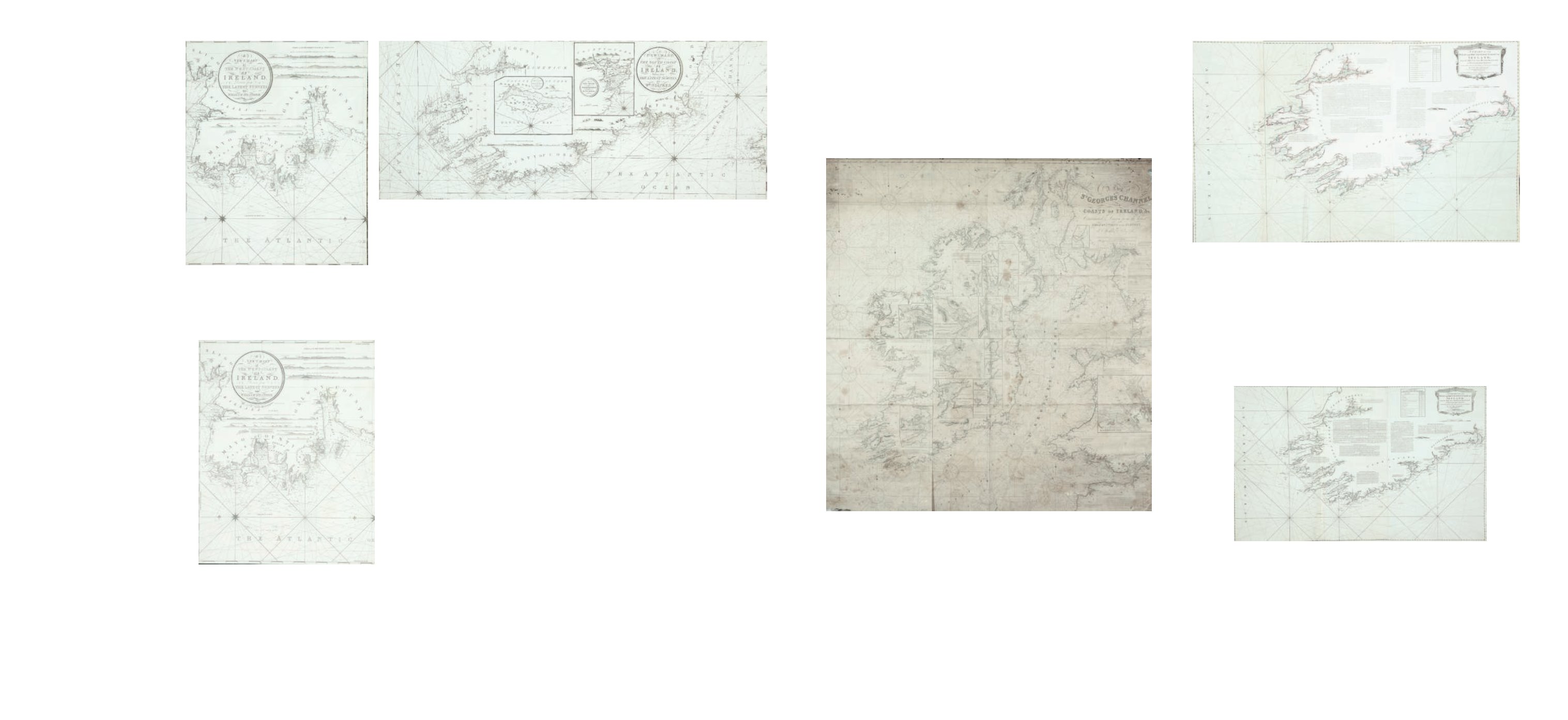
160
Huddart
Chart of the South-West Coast of Ireland
This chart was first published in 1780 by Sayer and Bennett on three sheets, and was
included in their East India Pilot of 1781. The title is in a classical rectangular frame in
the top right corner and reads
“A Chart of the West and South-West Coast of Ireland from
the Mouth of the River Shannon to Waterford Haven on the same Scale as the Chart of
St. George’s C hannel. By Capt. Jos. Huddart. London. Printed for R. Sayer and I. Bennett,
Fleet Street, As the Act directs, August 1st 1780”. Below this is an unframed “Scale of Nautic
Leagues 20 to a Degree 8 [= 156 mm.]”.
1.270 x 785 mm.
€ 300 - 500
154
William Heather
Chart of the West Coast of
Ireland
This is part of a series of three charts
covering the north, west and south
coast of Ireland, first published in
1807. It overlaps chart IV to include
Sligo town and butts on the chart VI
to the south.
It shows the coast from Sligo town to
Mutton Island in Galway Bay. The title
is in a circular frame in the centre
and reads
“A New Chart Of The West
Coast of Ireland. Drawn from The
Latest Surveys by William Heather.
1807”.
625 x 785 mm.
€ 200 -400
156
William Heather
Chart of the South Coast of Ireland
This is part of a series of three charts covering the north, west and south coast of Ireland, first produced in
1807. It butts on to chart VI to the north.
It shows the coast from county Clare to Arklow, county Wicklow, and part of south-west Wales. The title is
in a circular frame in the centre right and reads
“A New Chart of the South Coast of Ireland Drawn from the
Latest Surveys by Wm. Heather. 1807”.
775 x 1,290 mm.
€ 0 - 0