


 56-57 / 160

57
www.adams.ieThe R.S.J.Clarke Collection of Cartography
15
th
December 2015
116
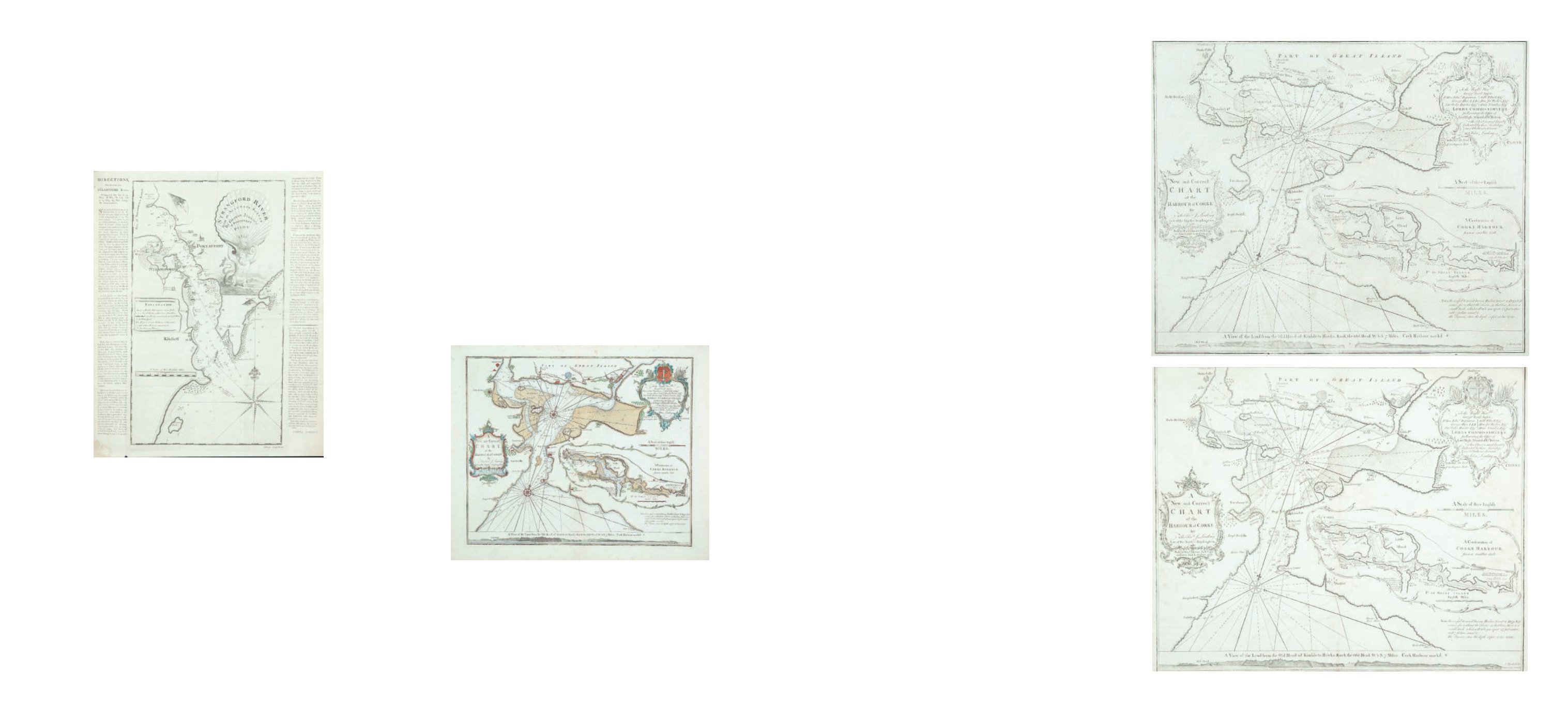
The Rev J Lindsay I.
A New and correct Chart of Cork Harbour
“A New and Correct Chart of the Harbour of Corke by the Revd. J. Lindsay, Late of His
Majesty’s Ship Fougueux. Sold by W. & I. Mount, T. & T. Page on Tower Hill, London.
1759.”
A dedication in a similar frame in the upper right corner reads
“To the Right
Honble. George Lord Anson, Rt. Hon. Edwd. Boscawen, George Hay LLD., Thos. Orby
Hunter Esqr., Gilbt. Elliott Esqr., Hon. Jno. Forbes Esqr., Hans Stanley Esqr., Lords
Commissioners for Executing the Office of Lord High Admiral of Gt. Britain, This Chart
is most Humbly Dedicated by their Lordships most Obedient Servant John Lindsay”
.
Below this, unframed, is
“A Scale of three English Miles 3 [= 107 mm.]”
. TThere is an
inset (120 x 305 mm.) in an irregular scalloped frame showing
“A Continuation of
Corke Harbour from a smaller Scale”
. The scale of this reads
“English Miles 3 [= 66
mm.]”.
512 x 433 mm.
€ 300 - 400
117
The Rev J Lindsay I.
A New and correct Chart of Cork Harbour
512 x 433 mm.
€ 300 - 400
George Johnston is described on his chart of 1755 as a pilot of Portaferry, but
no other record of him has been found. From the text alongside the second edition of
the chart, it appears that he was dead by 1782 and presumably the Samuel Johnson who
reprinted it was a son. Estate rentals of Portaferry in the Public Record Office of Northern
Ireland record a “widow of George Johnson” in 1772 and 1773. The form of the name
“Johnston” was only used in the first edition, whereas “Johnson” was used in the 1782 and
1839 versions.
The chart of Portaferry was engraved by John Ridge of Dublin, who also
engraved a map of County Cork in 1750 and Charlevoix’s British Dominions in N. America
in 1766.
The Reverend John Lindsay’s origins are unknown, as is his place of education, but
he is first heard of as chaplain in the Royal Navy in 1755 (Taylor, 1978). In 1757 he was chaplain
on H.M.S. Fougueux (64 guns, 500 men), under Captain Augustus Keppel (late r Admiral and First
Viscount Albermarle). At this time they were in Cork, but he was on the expedition which cap-
tured the island of Goree in French West Africa in December 1758, and described his experiences
in A Voyage to the Coast of Africa in 1758 containing a succinct account of .... taking of .... Goree,
London, 1759. A Voyage to Senegal and Sir John Tostle, a Poem are ascribed to the same author.
His brother William, brigade-major in Lord Ancrum’s troop of dragoons, fell in the Seven Years
War (Lives of the Lindsays, II, 173-174; D.N.B., XXXIII, 307).
The chart of Cork is based on a survey started in 1757 when H.M.S. Fougueux was
in Cork for a period. Lindsay observes in the Voyage, to explain why he undertook the work, that
the old charts were poor being “laid down by the antient rule of thumb and even in that way itself
finished in a very bungling manner.” He mentions a former chart of Cork, published in Dublin and
borrowed from the Earl of Inchiquin (? Collins’ chart). Lindsay says that he “laboured a good deal
upon it and for the greater exactness took the principal angles with Hadley’s quadrant as well
as the theodolite; and when they differed took the mediums. But I had not been in the harbour
six weeks [in 1757] before my ship returned to England, when I left the draught unfinished”. On
returning to Cork after this visit to Spithead, as they were passing through the narrow part of the
estuary, the Fougueux and the Nassau collided, doing considerable damage to the Fougueux.
While it was being repaired Lindsay continued the survey but went with the ship on the expe-
dition to Goree early in 1758. The Fougueux was finally scrapped on returning to England after
this. Lindsay returned to Cork in November 1758 to complete the work and it was first published
in his Voyage to the Coast of Africa.
The chart was also published, with minor changes, in the 1759 edition of Seller’s The
English Pilot and appeared in subsequent editions of this and Collins’ Great Britain’s Coasting
Pilot until 1792. No details of John Lindsay’s later career are known.
115
The Rev J Lindsay
A New and correct Chart of Cork Harbour
“A New and Correct Chart of the Harbour of Corke by the Revd. J. Lindsay, Late of His Majes-
ty’s Ship Fougueux. Sold by W. & I. Mount, T. & T. Page on Tower Hill, London. 1759.”
There is an inset (120 x 305 mm.) in an irregular scalloped frame showing
“A Continuation
of Corke Harbour from a smaller Scale”
. The scale of this reads
“English Miles 3 [= 66 mm.]”.
Below the chart is a coastal profile entitled
“A View of the Land from the Old Head of Kinsale
to Hawks Rock, the Old Head W b S 7 Miles. Cork Harbour marked * “
. 512 x 433 mm.
€ 300 - 400
114
George Johnston
Chart of the Entrance to Strangford Lough
This is an isolated chart, surveyed and presumably published by George
Johnston in 1755. The first state gives no engraver’s name, but the second state gives it as
John Ridge of Dublin.
It shows the entrance to Strangford Lough, with the mainland from Gunn’s Island to Castle
Ward, and the Ards coast from Millin Bay round Ballyquintin Point to Ballywhite Bay. It
gives soundings and anchorages but little inland detail. The title in the top right corner
reads
“Strangford River from an Accurate Survey by George Johnston of Portaferry Pilot
1755”,
and is depicted on a shell supported by a sea-god. The cartouche is very similar
to that of Greenvile Collins’ title page for his Great Britains’ Coasting Pilot, except that the
figure is facing left instead of rig ht. There are three ships alongside this figure, and some
houses, castles and churches are illustrated. In the middle left is an “Explanation” or key
to the symbols and depth markings. In the lower left corner is
“A Scale of Two English
Miles 2[= 119 mm.]”.
There is one compass rose showing north to the top, but no scale of
latitude or longitude. The frame consists of two parallel lines. 295 x 525 mm.
€ 150 - 200
George Johnston
The Rev J Lindsay