


 48-49 / 160

49
The R.S.J.Clarke Collection of Cartography
15
th
December 2015
105
William Doyle
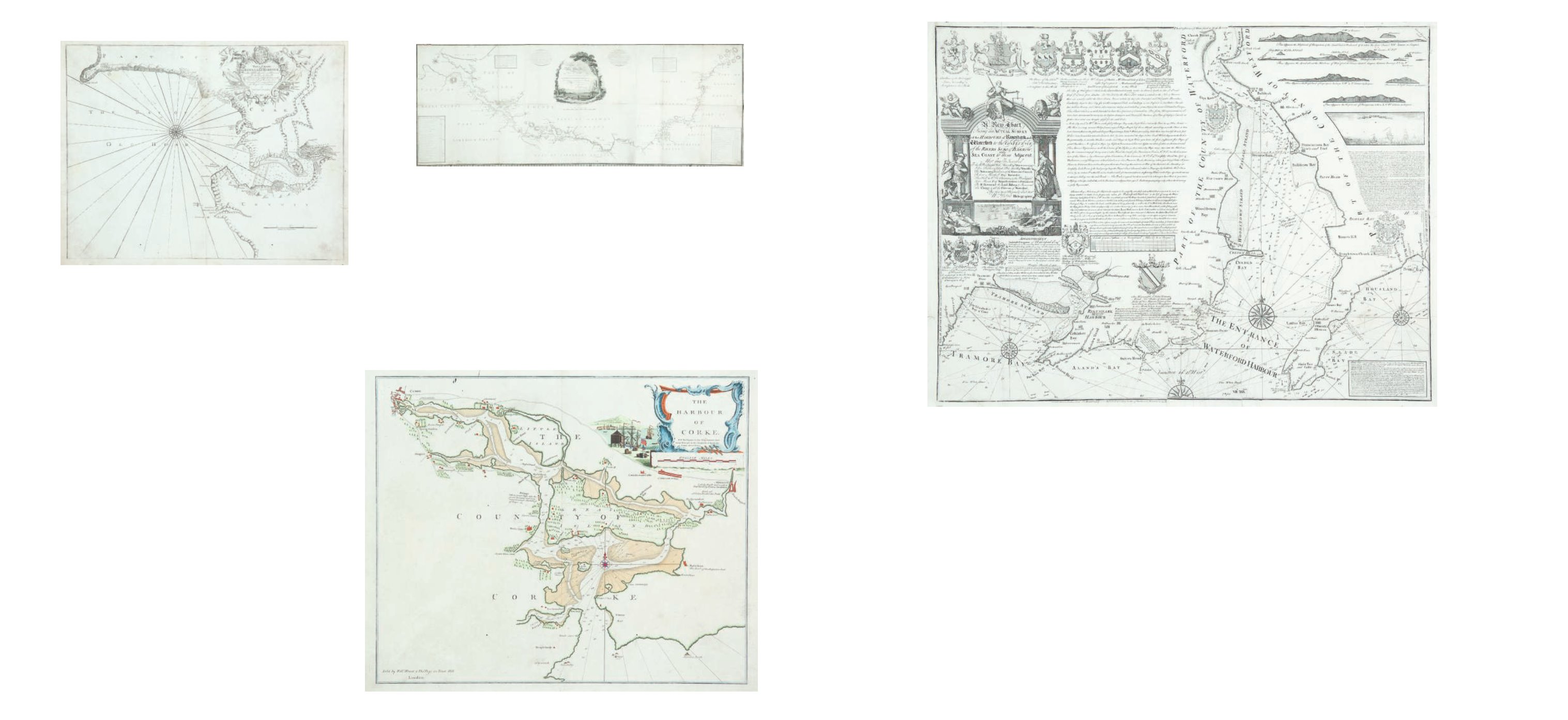
A Chart of Waterford Harbour
First published in 1738. 725 x 565
William Doyle, hydrographer, of Dublin, is known mainly for his survey of the Water-
ford area, carried out in 1736 and published as a chart in 1738, both in London and in Dublin. He
had already discovered, on 15th July 1736, the Nymph Bank, a shallow area south-east of Ireland
rich in fish, which is marked prominently on many of the later eighteenth century maps. Doyle’s
chart, with considerable additions from Mackenzie’s survey, was used in producing the Sayer chart
of 1787,
This is presumably the first printed version of William Doyle’s chart of Waterford Harbour, en-
graved by Emmanuel Bowen of London and published by Denis Cherry on 25th Jan. 1738.
It shows the south Irish coast from Great Newtown Head to Baginbun Head,and
north to the confluence of the Suir and the Barrow. It has a title in an ornate frame, flanked by
pillars with a figure of Mercury and a female figure holding rolls of cloth. Above are two cupids
with a cornucopia and a beehive. Below are sea-gods representing the “Barrow” and the “Sure”,
with a maritime scene between them. The title reads “A New Chart Being an Actual Survey of
the Harbours of Rineshark and Waterford to the Confluence of the Rivers Sure & Barrow and
Sea Coast to them Adjacent, Most Humbly Inscribed To the Rt. Worshipful Heny. Mason Esqr.,
Mayor anno 1735; John Barker & Joseph Price Junr. Esqrs., Sheriffs; The Aldermen & Gentlemen of
the Common Council; Robert Marshell Esqr., Recorder; The Honble. Coll. Thos. Christmas & the
101
Greenville Collins (1653-1693)
A Chart of Kinsale
No name at bottom left.575 x 450
€ 200 - 400
103 John Cowan (1794)
A Chart of the River Shannon
1,980 x 400
€ 200 - 400
John Cowan, surveyor, flourished in Dublin during the late eighteenth century.
He produced a set of charts of the river Shannon in 1771-3, followed by a version on a
reduced scale c. 1795. He also published a chart of Dublin Bay in 1800.
The engraver of the first of the Shannon series was Thomas Bowen of
Clerkenwell, London, who engraved maps and charts for many British atlases between
1760 and 1790 when he died. The other two charts in this series were engraved by
John Duff, who worked in Dublin during the same period. He was deaf and dumb from
childhood and carried on business at 13 Smock Alley, 44 Essex Street, and finally at 17
102
Greenville Collins (1653-1693)
A Chart of Cork Harbour
from the Second English plate of the chart in the 1690. Published by Mount &
Page.
520 x 430
€ 300 - 500
Worshipful John Mason Esqr., Representatives in Parliament; The Rt. Reverend the Lord Bishop &
Reverend the Clergy & all the Citizens of Waterford, By their most Devoted & obedt. servt. Wm.
Doyle Hydrographer.”
There are 12 coats of arms spread over the chart: (along the upper edge) (1) John
Mason, (2) the City of Waterford, (3) Coll. Thos. Christmas, (4) Rev. Alexander Alcock, (5) Wm.
Lingen, (6) Edmund Field, and (7) Edward Stephen; (below the title) (8) the Rt. Hon. Eliz Viscountess
of Donerayle and Baroness of Kilmeaden, (9) blank, (10) Rt. Rev. Thomas Miles, and (11) John
Fortesque Alard; (in the centre right) (12) “Brice Seede of Bitton in Gloucestershire Gent. to whose
memory the Nymphs Bank is most gratefully Inscribed by W. Doyle”.
At the bottom below the frame, is the imprint of “Emanl. Bowen Londini Sculpt. For
Denis Cherry - Publish’d according to Act of Parliament January 25 1737/8”. There is in the centre,
in a rectangular frame, “A Scale of 2000 Fathoms or 2 Geometrical Miles 60 to a Degree 2 [= 128
mm.]”. Below the title is an “Advertisment Ambrose Congreve of Waterford Esq. hath adjacent
to the said City, Built a very convenient Dry Dock .... Waterford, December 10th 1737”. In the top
right there are many coastal profiles and below them an engraving entitled “The Nymph Bank”
with a description of William Doyle’s finding this on 15th July 1736. In the lower right corner is
a note on Slade Pier. There are 3 1/2 compass roses showing north to the top, but no scales of
latitude or longitude.
€ 700 - 900