


 38-39 / 160

39
www.adams.ieThe R.S.J.Clarke Collection of Cartography
15
th
December 2015
The Depot General des Cartes et Plans de la Marine et des Colonies was the French government
department which was responsible during the latter eighteenth century for the publication
of charts for the French navy. It ordered the publication in 1753 of Bellin’s new edition of Le
Neptune Francois and with it in 1757 Bellin produced five new charts of the British Isles. For the
former Bellin used Pene’s old plates as far as possible, and the three Irish charts are described
under the name of Pene, while the 1757 set are described under Bellin’s name. Not until 1773
was the circular mark of the Depot de la Marine added to the Pene and Bellin charts. This mark
and other features of the charts were modified after the Revolution.
The French navy were beginning to appreciate by 1798 the surveys of Arnold,
Huddart, Mackenzie, Moore, etc. and to obtain up-to-date charts of the British coast for their war-
ships, they copied the various British charts, particularly Huddart’s charts of Ireland. These will
all be described below, with references to the older charts from which they are copied. Besancon
and d’Houdan were engravers with the Depot de la Marine who signed some of the charts. Many
of the charts exist in at least two states, one of which has the year in the usual calendar, while the
other uses the revolutionary calendar. The year VI ran from August 1797 to August 1798 and the
year XII from August 1803 to August 1804. However, in May 1804 Napoleon was declared “Em-
peror of the French” so that the initials “E.F.” presumably indicate a chart issued after this date. In
fact, the sequence of the various states is not always clear and often they were simultaneous or
nearly so.
Many of the French charts have red numbers stamped on the front and/or hand-writ-
ten numbers on the back, from the volume in which they were contained until recently, but these
numbers will not be described here. All charts came from Volume IV or the British Isles volume of
Le Neptune Francois. It is usually undated and the contents page gives only a vague idea of the
actual number of charts.
The extensive collection of loose charts, both printed and manuscript, and mainly of
pre- 1800 date, belonging to the Depot de la Marine, were eventually transferred to the Departe-
ment des Cartes et Plans of the Bibliotheque Nationale. There they are catalogued separately in
a typewritten volume entitled “Liste des Cartes Cedees a la Bibliotheque Nationale par le Service
Centrale Hydrographique de la Marine (cartes anterieures a 1800 .... “. Approximately one-third of
these charts are manuscript. They are stored by Portfeuille number, division number and piece
(item) number, and in addition, there is a subdivision into large and small items.
The sea atlases remained with the Service Historique de la Marine in its new home in
the Chateau de Vincennes (Pavillion de la Reine). These include atlases by Bellin, Collins, Colom,
Goos, van Loon and Waghenaer, but not all are catalogued so that they are somewhat difficult to
obtain.
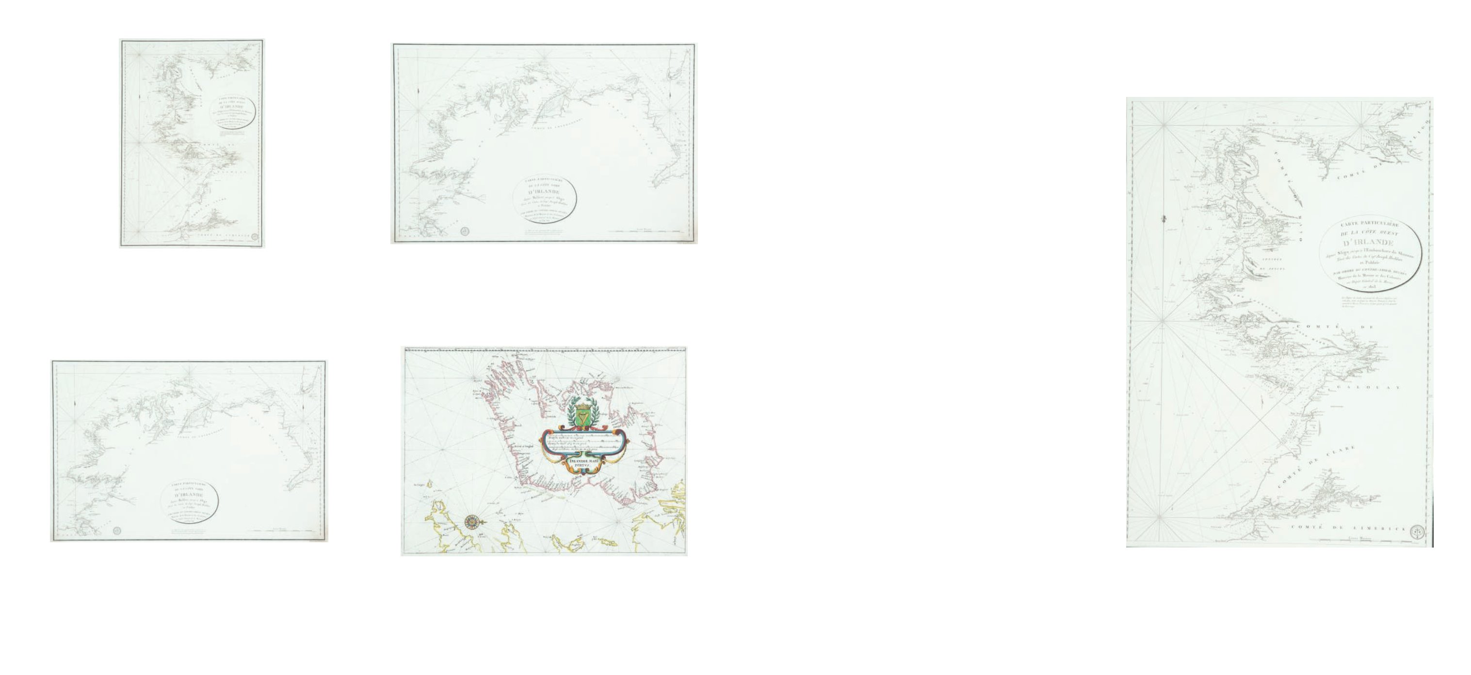
77A Depot de la Marine VII.
Chart of the West Coast of Ireland (530 x 765 mm)
This chart is in the volume of Le Neptune Francois of 1803, covering the British Isles, based
on an earlier chart of Captain Joseph Huddart (chart V).
It shows the west coast of Ireland from Mullaghmore, county Sligo, to Kerry Head, county
Kerry. The title is in an oval frame in the centre right and reads
“Carte Particuliere de la
Cote Ouest d’Irlande depuis Sligo jusqu’a L’Embouchure du Shannon Tiree des Cartes du
Cape. Joseph Huddart et Publiee Par Ordre du Contre-Amiral Decres Ministre de la Marine et
des Colonies au Depot General de la Marine en l’An XII”.
Below this is a note on the soundings. In the lower right corner is a scale of
“Lieues
Marines 10 Lieues [= 171 mm.]”
and beside this is the circular mark of the Depot Gal. de la
Marine R.F.” and below both, outside the frame, is
“Prix Deux Francs”.
There is one com-
pass indicator with an arrow showing north to the top, and scales of latitude on each side.
€ 100 - 200
74
Jacques Nicolas Bellin (1703-1772)
A Chart of the West Coast of Ireland (1803)
“Carte Particuliere de la Cote Ouest d`Irlande depuis Sligo jusqu`a l`Embouchure du
Shannon….”,
with “Depot Gal. de la Marine” and fleurs de lis mark, “Prix Deux Francs” below and “No.
53” in the top right. (1803). 525 x 770.
€ 100 - 200
76
Jacques Nicolas Bellin (1703-1772)
A Chart of the North of Ireland
“Carte Particuliere de la Cote Nord d`Irlande depuis Belfast jusqu`a Sligo….”,
with “Depot Gal. de la Marine R.F.” mark and “Prix Deux Francs” in lower right corner.
(1803). 795 x 525 [2 copies].
€ 100 - 200
77
Jacques Nicolas Bellin (1703-1772)
A Chart of Ireland (1641)
“Irlandiae Mari Portus”, from De Rebus Publicus Hanseaticus Tractus (1641) by Johan Ange-
lius Werdenhagen.
It is a direct copy of Blaeu`s chart in the Zeespiegel. Verso blank. 350 x 260.
€ 200 - 300
75
Jacques Nicolas Bellin (1703-1772)
A Chart of the North of Ireland
“Carte Particuliere de la Cote Nord d`Irlande depuis Belfast jusqu`a Sligo….”,
with “Depot Gal. de la Marine R.F.” mark and “Prix Deux Francs” in lower right corner.
(1803). 795 x 525 [2 copies].
€ 100 - 200
Depot de la Marine