


 44-45 / 160

45
www.adams.ieThe R.S.J.Clarke Collection of Cartography
15
th
December 2015
Greenvile Collins served in the Royal Navy as a young man and accompanied Nar-
borough’s voyage to the South Seas, 1669-71, later becoming master of Narborough’s flagship
Plymouth. During the period 1676-79 the journal that he kept while in the Mediterranean was
copiously illustrated with hydrographic sketches (Dyer, 1928) and he was already developing
an interest in coastal topography. About this time it also became obvious to the Admiralty,
from John Seller’s experience of publishing his English Pilot, that a proper survey of the English
coast was required. Captain Greenvile Collins was therefore appointed “Hydrographer to the
King” in 1681, to survey the coasts and inshore waters. Charles II supported the scheme with
money and a suitable ship and Collins was appointed a Younger Brother of Trinity House in the
same ye ar. However, the survey was always short of money and, since land mapping was also
needed, it lasted until 1688 limited though it was. The text lists on p. 24 the years in which dif-
ferent areas were surveyed, and in 1687 (the last complete year of the work) he notes that he
“Surveyed Liverpool, the Isle of Man, Carrackfergus, Dublin, Kinsale and Cork, which is all that
is surveyed, and is the most useful and necessary part to Navigation.” He adds “I could heartily
wish that the West Part of Ireland and Scotland may hereafter be surveyed &c.” Collins died
intestate in March 1694 and administration was granted in April of that year at t he Prerogative
Court of Canterbury (Verner, 1969).
Collins prepared 120 plans of harbours and coastlines, but only 48 were finally
engraved and used. Many of the manuscript charts are lost but that of Dublin Bay has survived
(see Chart I). Engravers included J. Harris, Francis Lamb, James Clark, James Moxon and
Herman Moll, though most of the charts are unsigned. The only named engravers of the Irish
charts are John Harris for Carlingford and Kinsale, and James Collins for Belfast Lough, though
the imprint of the latter (below the cartouche on the right) is usually worn away.
Great Britain’s Coasting Pilot was first published in London by Richard Mount in
1693, and 18 English editions followed up to 1792, all printed by the firm of Mount and Page.
There were five Irish charts finally printed, covering the harbours of Belfast, Carlingford, Dublin
Cork and Kinsale, as well as the chart of St. George’s Channel, and in the last edition only,
Thornton’s chart of all Ireland is included.
Five of the Irish charts appear in two different states in the first edition (St.
George’s Channel, Belfast, Carlingford, Dublin and Kinsale), map numbers, cartouches or
other material being added in the later version. There is no consistency as to which copies of
the 1693 edition have the first version of the charts, and the form of the chart in the various
versions is noted below. The chart of St. George’s Channel was advertised separately in the
London Gazette, May 15-19 1690 (Tyacke, 1978), indicating that the first state at least, was
ready by that date. Vice-Admiral Sir Richard Rooth, to whom the chart of St. George’s Channel
was dedicated in its second state, was Governor of the forts at least as early as October 1680.
He left in 1691 and his successor, the Hon. Charles Mainwaring, was Governor by October
1691 (Caulfield, 1879), suggesting that even in its second state this chart was engraved before
the latter date, though old stock of State 1 was used until finished. The chart of Cork has not
Collins’ name and does not appear in the first edition of Great Britain’s Coasting Pilot, but he
records having surveyed the area in 1687 and we may assume that it was by him. It was first
published in Seller’s The English Pilot in the “1690” and subsequent editions, reaching Great
Britain’s Coasting Pilot in the second edition of 1723. A new plate was made for the 1744 edi-
tion and the new survey by the Rev. J. Lindsay (q.v.) for the 1760 editions of The English Pilot
and Great Britain’s Coasting Pilot.
Certain plates were re-cut c. 1774 (St. George’s Channel, Belfast, Dublin, Lindsay’s
Cork and Kinsale) but were not all introduced together. The 1779 editions in the N.M.M. and
N.L.W. contain new versions of only Belfast Lough and Kinsale.
A French edition of Collins’ work was produced in 1757 by Jacques Nicolas Bellin
(q.v.), using the 1723 charts as a basis.
A list of charts is given by Robinson (1962) and a detailed analysis was carried out
by Coolie Verner (1969), though both have some omissions.
93
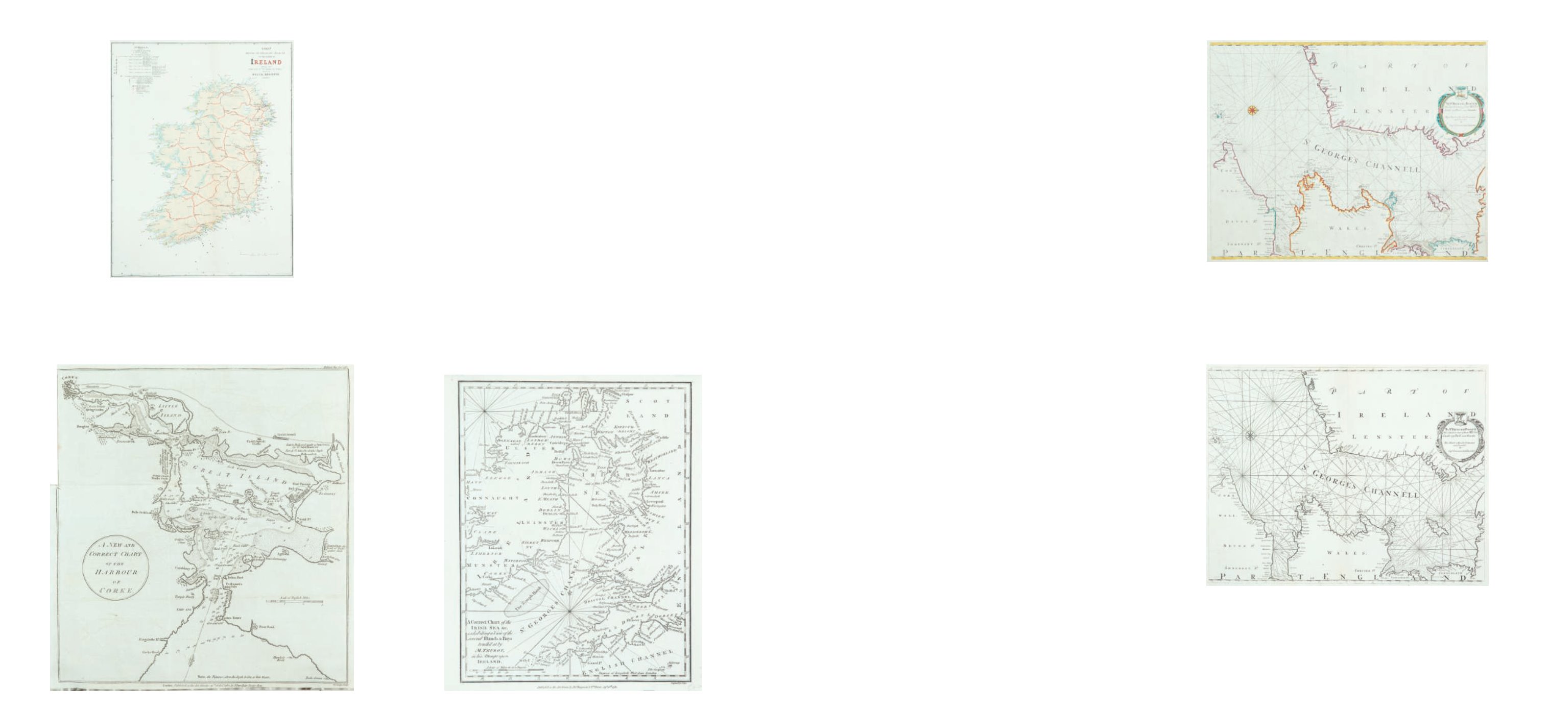
Greenville Collins (1653-1694)
A Chart of St. George’s Channel
From Great Britain’s Coasting Pilot. First published in 1693. This copy second state.
575 x 455
€ 250 - 350
94
Greenville Collins (1653-1694)
A Chart of St. George’s Channel
From Great Britain’s Coasting Pilot. First published in 1693. This copy third state.
575 x 455
€ 250 - 350
90
Board of Trade
A Chart of the Irish Coast
Showing the wrecks (1867).
€ 50 - 100
92
John Carey
A correct chart of the Irish Sea
€ 50 - 100
John Cary was born c. 1754, the second son of George Cary of Warminster, Wiltshire
(Fordham, 1925). He was apprenticed to William Palmer of New Street Square, London,
engraver, for seven years from 1770. Two years after the expiration of his apprenticeship,
in 1779, he married Ann Jackson of St. James’, Clerkenwell. By her he had three sons,
George, John and Thomas, and a daughter Mary Ann. George (d. 1859) and John (c. 1791 -
1852) joined their father in the business and ran it after his death with George F. Cruchley.
Ann died in 1824 aged 72 at King’s Road, Chelsea, and was buried at Kensington on 1 July
1824.
91
John Bew (1774-1793)
A New and correct chart of the harbour of Cork
based on the Rev. John Lindsay’s Chart of 1759. It is from The Political
Magazine (1782) 285 x 315
€ 200 - 400
John Bew was a bookseller and published at 28 Paternoster Row, London,from 1774 to
1793. An edition of Maitland’s History of London dated 1775 was published by J. Wilkie, T.
Lowndes and J. Bew. He later published the monthly parts of The Political Magazine from
1780 to March 1785, when it was taken over by John Murray of 32 Fleet Street. During this
period he produced a number of interesting maps of various parts of the world, including
the chart of Cork Harbour in 1782
Greenville Collins (1653-1694)
91