


 20-21 / 160

21
The R.S.J.Clarke Collection of Cartography
15
th
December 2015
27
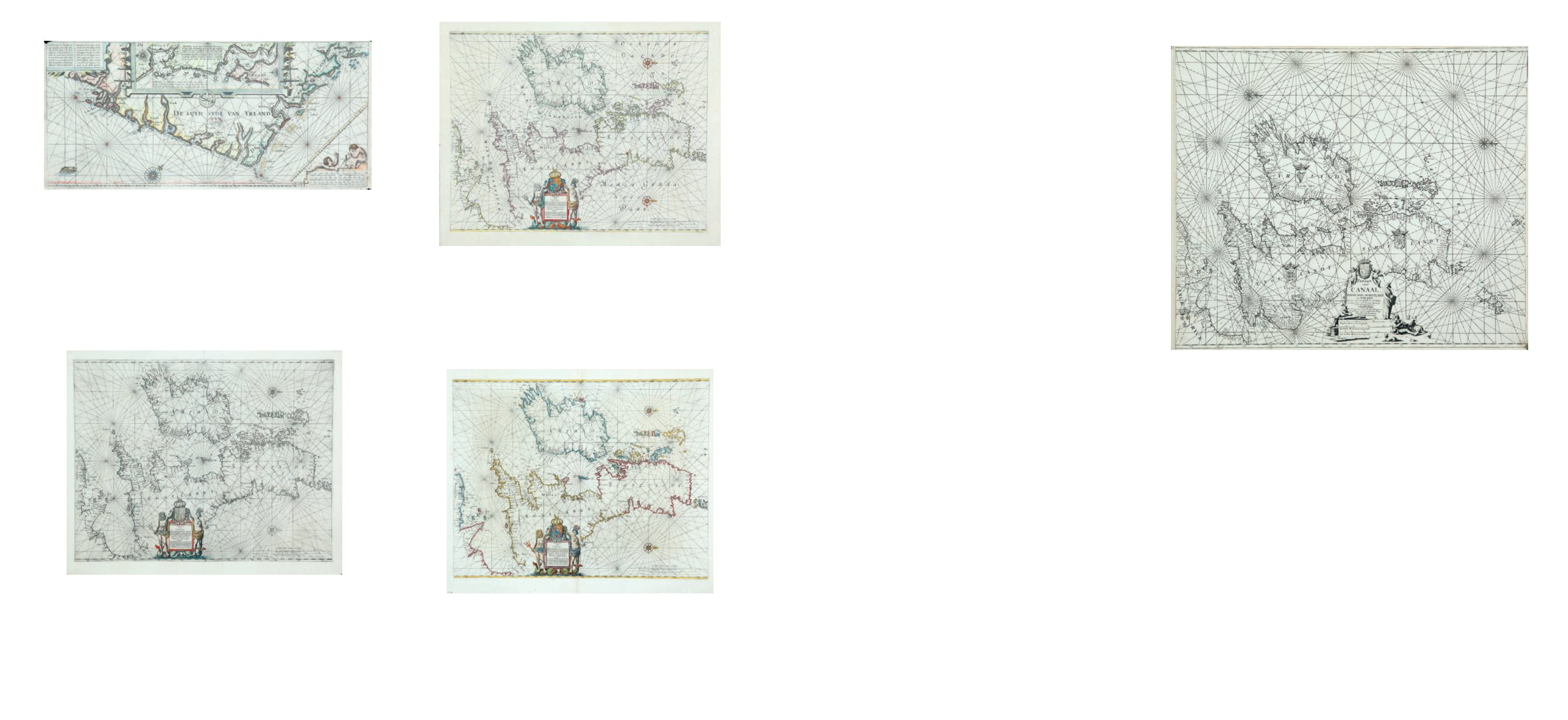
Keulen, Johannes van (c.1654-1715)
A Chart of Ireland and the Irish Sea (1680)
“Pascaart vande Canaal Engeland, Schotland en Yrland,
Synde vande miswysingh en veel fouten verbetert door veel
Ervaerne Stierlieden. T`Amsterdam. By Ioannes van
Keulen, Boeckverkooper en Graedboogh maecker aende
Nieuwbrug inde gekroonde Lootsman. Met Privilegie voor
15 Iaar.”
From De Groote Nieuwe Vermeerdende Zee-Atlas
Ofte Water-Werelt (1680). It is oriented with North to the
right. Verso blank. 605 x 520.
€ 300 - 400
Keulen, Johannes van (c.1654-1715)
Johannes van Keulen was born at Deventer about 1654, the son of Gerrit van Keulen
and Machteld Pouwels. The family probably moved to Amsterdam after 1656. In 1678 Johannes
was enrolled in the booksellers’ guild, living at the Warmesstraat, and from 1680 he describes
himself on his title-pages as a book-seller and instrument-maker at the East End of the New Bridge
at the Sign of the Crowned Pilot. An advertisment in 1695 states that the charts were essentially
by Claas Jansz Vooght, mathematician, and it seems that van Keulen remained throughout only the
publisher. He enlarged his business in 1693 by buying up that of Hendrik Doncker who wished to
retire.
Johannes married Louise Coerten and had a son Gerard who was born in1678 and who
took over the business when his father died in 1715. Gerard was a skillful engraver and mathema-
tician, so that the atlases were steadily improved and the business flourished during his period of
control. Whereas Johannes was never appointed hydrographer to the East India Company, Gerard
held this post from 1714, as did his successors in the firm. Gerard died in 1726 at the relatively
young age of 49, and his widow Ludwina Konst ran the business with his son Johannes II. It contin-
ued to expand, and after he died in 1755 his two sons Gerard Hulst van Keulen and Cornelis Buys
van Keulen, followed on. Thereafter the business declined, especially in the phase 1757-78, to have
a brief resurgence when Gerard managed it alone after the death of Cornelis in the latter year. Ge-
rard died in 1801 and although the firm lasted until 1885 there were no important new productions.
Johannes van Keulen’s first publication was De Groote Nieuwe Vermeerderde Zee-Atlas
Ofte Water-Werelt which was published in 1680 in Dutch and French. Spanish and English editions
followed in 1682, and the whole was reprinted many times until the last edition of 1734. It is essen-
tially a one-volume atlas with little text. At first it had only 36 charts, but this number was increased
by taking over charts from the Zee- Fakkel, so that the largest edition (of 1708 and with 185 charts) is
in separate sections like the Zee-Fakkel. On the other hand the 1734 edition had only 25 charts, for
no apparent reason.
The other publication was De Nieuwe Groote Lichtende Zee-Fakkel, Parts I and II being
published in Amsterdam in 1681 with text in Dutch and French. This was a pilot-guide, like those of
the other Dutch publishers, with sections covering the main areas of the world. The Irish charts are
in Part II and this part continued to appear until 1803, including Spanish editions c. 1700.
From the outset (1680) the Zee-Atlas contained a chart of Ireland and the Irish Sea
similar to that by Doncker (1659), Goos (1666) and Jacobsz (1666), but showing more of England
and therefore closer to a chart of the British Isles (chart I). It occurs in most of the early editions
from 1680-84, but is found as late as 1694. It has not been seen in the Zee-Fakkel. After 1685 it was
sometimes replaced by a chart oriented with north to the left unlike that of any other cartographer
(chart II). This latter chart was used in the Zee-Fakkel from the first edition of 1681. Its geographical
details are similar, though it is somewhat more decorative with its ship, and larger figures in the
cartouche. Additions to the chart, including a sandbank and the imaginary island of “Brazil”, were
made for different editions within a short time around 1700. Confusion in the states arises because
of the difficulty in dating the two Spanish editions of the Zee-Fakkel.
There are four regional Irish charts (III - VI), which first appeared in the Zee-Fakkel, Part
II, of 1681. They occur in the English edition of the Zee-Atlas of 1682 (N.M.M. and R.G.S.), but Koe-
man describes it as having “been enlarged with several extra charts”. However, they did not officially
reach the Zee-Atlas until the edition of 1688, and they are not in the 1682 or 1684 Dutch or English
editions in the B.L. These charts were all modified for the 1704 Zee-Fakkel and that of south-west
Ireland had an additional modification, as is indicated in the detailed descriptions below.
Two larger charts (VII and VIII) appeared later in the Zee-Fakkel, one of Ireland and
the Irish Sea in 1718, and the other of southern Scotland and northern Ireland in 1728, both being
used sometimes instead of chart IV. In the 1734 edition four new charts (IX - XII) were introduced,
covering the main harbours of Ireland. They were produced by Johannes II, though they were
signed by Gerard van Keulen. Three of them had the imprint of Gerard Hulst van Keulen inserted
later. Finally, there are two charts (XIII and XIV) of 1802/3 which are not in Koeman but are signed
by the widow of G.H. van Keulen. On the whole the 1681 charts are decorative, attractively laid out
and approximately up to date. The later group are innacurate, with little decoration and are clearly
derived from British surveys.
25
Johannes Janssonius (1588-1664)
A Chart of Ireland and the Irish Sea (1652)
“Pascaart Vant Canaal Tusschen Engelant en Vrancryck alsmede geheel Jerlant en Schotlant,
waer in men clear can sien de rechte distantien en courssen tusschen alle havens
endroogte, alles opt syn ware hoogten geleyt.”
Also a version of this in Latin. This is a close
copy of Jacobsz`s chart in De Zeespiegel (1652). Verso text in Latin, ending on right half
“Sff -thieu”. 550 x 430.
€ 300 - 400
26
Johannes Janssonius (1588-1664)
A Chart of Ireland and the Irish Sea (1652)
“Pascaart Vant Canaal Tusschen Engelant en Vrancryck
alsmede geheel Jerlant en Schotlant, waer in men clear can
sien de rechte distantien en courssen tusschen alle havens
endroogte, alles opt syn ware hoogten geleyt.”
Also a version of this in Latin. This is a close copy of Jacobsz`s
chart in De Zeespiegel (1657). Verso text in Dutch. 550 x 430.
€ 300 - 400
24
Janssonius, Johannes (1588-1664)
A Chart of Ireland and the Irish Sea (1650)
“Pascaart Vant Canaal Tusschen Engelant en Vrancryck
alsmede geheel Jerlant en Schotlant, waer in men clear can
sien de rechte distantien en courssen tusschen alle havens
endroogte, alles opt syn ware hoogten geleyt.”
Also a version of this in Latin. This is a close copy of Jacobsz`s
chart in De Zeespiegel (1650). Verso text in Latin, ending
on right half “Aaa bit”. 550 x 430.
€ 300 - 400
23
Janssonius, Johannes (1588-1664)
A Chart of the South-east Coast of Ireland (1650)
“Beschrijvinge der Zeecusten vande Suijd-sijde van Ierlant
…..” and “Description des costes marines meridionales et
Orientales d`Irlande ….”;
long title in Dutch and French for
this chart based on Blaeu`s chart of south-east Ireland.
There is a large meridian bar above the scales and map
number “16” in the lower right corner. From Het Licht der
Zeevaert (1620). Verso blank. 540 x 250.
€ 300 - 400