


 10-11 / 160

11
www.adams.ieThe R.S.J.Clarke Collection of Cartography
15
th
December 2015
Jacob Aertsz Colom
was born in 1600, probably in Dordrecht, which
he left in 1622. He then settled in Amsterdam and became a member of the booksellers’
guild. He married Barbetge Jans and had a son Arnold, who was born in 1623/4, and a
daughter Johanna who married the bookseller Pieter van Alphen of Rotterdam. He was
competing with Willem Janszoon Blaeu as a bookseller from the outset and in 1627 bought
a house in the same street as his rival, “op’t water”. From there he published a series
of atlases, pilot guides and globes, and for his lifetime at least, it was one of the most
successful publishing businesses in Amsterdam.
In 1632 he brought out his pilot guide De Vyerighe Colom which ran to
many editions by 1662. It is an upright folio volume in two “books”, with a general chart
of Ireland and the Irish Sea, and three pages of detailed Irish charts in the second book
(Western navigation), each page containing an upper and a lower chart (III - V). The gener-
al chart (I), which covers the western half of Great Britain from the Shetlands southwards,
became a pattern for similar charts by Doncker, Goos, Jacobsz and van Loon later in the
century. He later published a third book covering the Mediterranean. The first English
edition (The Fierie Sea Colomne) came out in 1633 and the last (The True and Perfect Fijrie
Colom) in 1668. The French editions (L’Ardente ou Flamboyante Colomne) ran from 1633
to 1662. The general chart was later re-engraved on a new plate (II) after the early edi-
tions, and two of the pages with two charts on each (IV and V) were split into two (VI - IX).
In 1648 Colom published his Upright Fyrie Colomne in oblong format, in an
English edition and in 1662 in a Dutch edition. In this there were seven Irish charts (X -
XVI), but the Western navigation was now printed as the first book.
Jacob Colom’s next publication was De Groote Lichtende ofte Vyerighe Colom,
in a large folio edition. It was published only in Dutch in 1651, 1652, 1653 and 1661, and
there is little difference between the editions. There were four Irish charts taken from the
Upright Fyrie Colomne, and one chart of the Bristol Channel from the same, but enlarged
to include part of the Irish coast (XVII). There is also a small chart of the Wexford area on a
text-page (XVIII).
Finally, in 1663 Colom produced his Atlas of Werelts-Water, a vertical folio vol-
ume with the last mentioned Irish chart in the 1668 (Dutch), 1669 (Latin) and 1669 (Spanish
and Portugese) editions. The chart entitled “ ‘t Canaal en Yerlandt Nieulijcx Verbetert door
Iacob Aertsz Colom. 1662.” is really a chart of the British Isles.
Jacob Colom died in 1673 and, since his son Arnold had pre-deceased him in
1668, the business passed to his grandson Jacob.
2
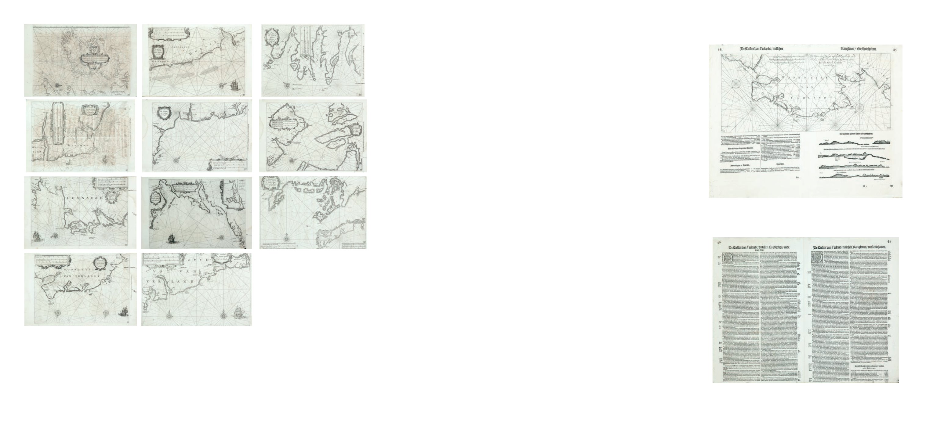
Willem Jansz. Blaeu (1571-1638)
Complete set of the eleven charts of the Irish coast,
from the1655 edition of the De Groote Zeespiegel, with text in Dutch
on the verso. These charts are from the same plates as the
1623 and later editions of Zeespiegel. Included are five
sheets of text and coastal profiles. Each chart 360 x 260.
(11)
€ 1,500 - 2,000
3
Colom, Jacob Aertsz (1600-1673)
The North Coast of Ireland with Coastal Profiles
“De Custen van Yerlant tusschen Ranghleens en de Stakes
van Brodhaven Nieulyx beschreven door Iacob Aertz.
Colom. Met Privilegie.
” This is a chart of the N-W coast of
Ireland on the upper half of the page with Dutch text and
coastal profiles below and the verso. It is from De Groote
Lichtende ofte Vyerighe Colom. (1651). 540 x 240
(chart only) or 540 x 440 (chart and text).
€ 150 - 250
Colom, Jacob Aertsz (1600-1673)