


 26-27 / 160

27
45
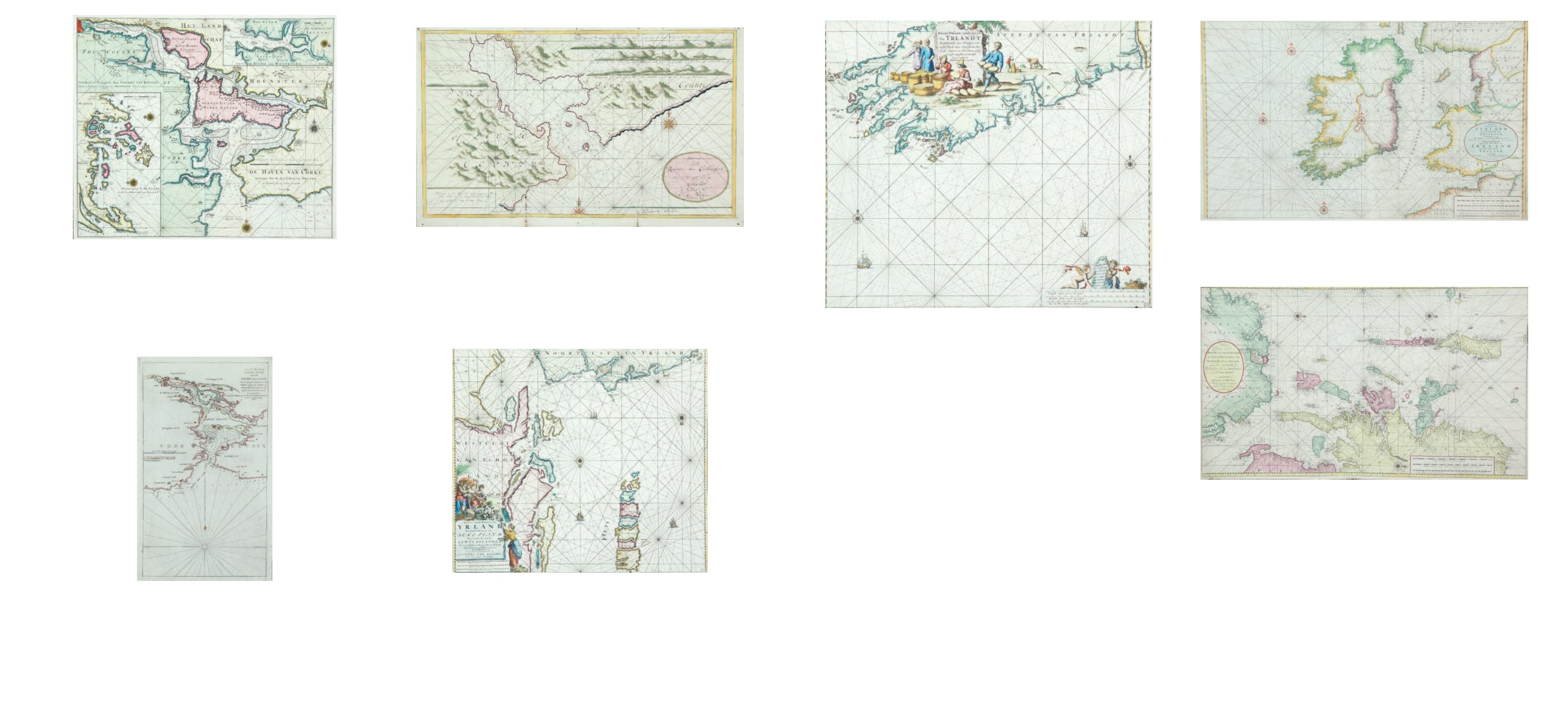
Johannes van Keulan (c.1654-1715)
Chart of the South-West Coast of Ireland
(580 x 505 mm.)
Koeman No. 80. There is a boxed “20” in the lower right corner. It occurs in van Keulen’s Zee-Fakkel from
the first edition (1681) to the last (1802), and in some of the editions of the Zee-Atlas from the English
edition of 1682.
The chart shows the south-west coast of Ireland, from the mouth of the river Shannon to Waterford. The
title is in the top centre in a loose frame, surrounded by a milkmaid milking, one churning, and others
carying and packing butter. Two fashionably-dressed men are standing nearby. The title reads
“Nieuwe Pascaert, van de suyt syde van Yrlandt Beginnende van Blasques tot ande Hoeck van Waterfoort,
Met al syn diepten en Droochten Naeu keurigh opgestelt, en van veel fouten verbetert. Met Priviligie voor
15 Iaar”. The publisher’s imprint is separate, on a tablet held up by cherubs in the lower right corner of the
chart, reading “ ‘t Amsterdam by Iohannus van Keulen boeck en Zee kaert verkoper an de Nieubrug Inde
gekroonde Lootsman”. Below this are the scales “Duytsche mylen 15 in een graet 13 {= 172 mm.] Spaensche
mylen 17 1/2 in een graet 15 [= 172 mm.] Eng. en Fra. mylen 20 in een graet 17 [= 170 mm.]”.
There are coastal soundings round Kenmare, Bantry, Kinsale and Cork. There are two compass roses
showing north at the top, and two ships, also scales of latitude on either side of the chart.
€ 200 - 300
46A Johannes van Keulan (c.1654-1715)
Chart of the North Coast of Ireland and W. Scotland
Koeman No. 244.
It occurs first in van Keulen’s Zee-Fakkel, Part 2, of 1728 (Dutch edition) as a replacement for
chart III, but not in the late editions where chart VI was used instead.
The chart shows the north coast of Ireland from the middle of the Ards peninsula to north
Sligo and the west coast of Scotland, including the Hebrides and St. Kilda. The Ards peninsu-
la, Island Magee and the tip of Innishowen are all shown as islands. The title, in a plain oval
frame over Ireland, reads “Nieuwe Paskaart van de West Kust van Schotland, de Lewys Ey-
landen en de Noord Kust van Yrland, beginnende van C Wrath of de Noordelykste hoek van
Schotland tot in het St. Ioris Kanaal. te Amsterdam by Gerard van Keulen Boek en Zeekaart
verkooper aan de Nieuwen brugh met Previlegie”. The scales are in the lower right corner in
a plain rectangular frame and read “Duytsche Mylen 15 in een Graad 15 [= 243 mm.] Englisch
Leagues 20 for Degree. Lieues de France 20 par Degrez 20 [= 243 mm.] Schotse Mylen van 50
in een Graad 24 1/2 [= 120 mm.] Ierse Mylen van 48 in een Graad 24 [= 122 mm.]”. There are
scattered soundings round the Irish and Scottish coasts, three compass roses showing north
to the right, and scales of latitude along the upper and lower borders. (1010 x 605 mm.).
€ 200 - 400
40 [= 91 mm.] Ierse Mylen van 48 in een Graad 40 [= 91 mm.]”. There are soundings
scattered round all the coasts as well as four compass roses showing north at the top and
scales of latitude on either side of the chart. (977 x 595 mm.).
€ 200 – 400
46
Johannes van Keulan (c.1654-1715)
Chart of Ireland and the Irish Sea
Koeman No. 298. It occurs first in van Keulen’s Zee-Atlas of 1718 and then in De Nieuwe Groote Licht-
ende Zee-Fakkel of 1734 and in some subsequent editions.
The chart shows all of Ireland and the coast of Great Britain from Land’s End to Ayr. In Ireland the Ards
peninsula, Island Magee, the tip of Innishowen and Mullet are all shown as islands. The title, in a plain
oval frame over Wales, reads “Nieuwe Paskaart van Ierland en de West kust van Engeland Vervattende in
sig St. Joris en het Verkeerde Kanaal, Gelegt naer de Nieuwste ondervinding van ervaren Zeelieden. The
New sea Map of Ireland and the West Coast of England containing St. George and the Channel of Bristol
made according the newest experience of Expert Mariners”. The publisher’s imprint is in a rectangular
frame with scroll-like ends, in the top right corner, and reads “te Amsterdam by Joannes Van Keulen Boek
en Zeekaart verkooper aan de Nieuwen Brug met Privilegie”. The scales are in the lower right corner
reading “Duytsche Mylen van 15 in een Graad 25 [= 184 mm.] Fransche Mylen van 20 in een Graad 33 1/3
[= 184 mm.] Engelsche Mylem van 60 in een Graad 100 [= 184 mm.] Schotse Mylen van 50 in een Graad
41
Johannes van Keulen (c.1654-1715)
A Chart of Cork Harbour and Baltimore Bay (1734)
“De Haven van Corke Geleegen Aan de Zuyd Kust van Irland de Dieptens syn in Voeten Ger-
steldt.” With separate imprint “Geteenkent en Uytgegeven door Gerardt Van Keulen, Boek
en Zeekaart Verkooper tot Amsterdam. Met Privilegie.”
There are also two insets of other parts of the south coast of Ireland. From De Nieuwe
Groote Lichtende Zee-Fakkel (1734). Verso blank. 585 x 500.
€ 600 - 1,000
43
Johannes van Keulen (c.1654-1715)
A Chart of Carlingford Lough (1707-1726)
“Aftenkening van de Rivier van Carlingfort gelegen aen de Oost Kust van Yrlandt tot Amster-
dam by G. van Keulen aan de Nieuen brughe.”
Based on Greenvile Collins` 1693 chart. Large working chart, folder twice vertically, with
“No. 26 Rivier Carlingfort” and “1707-1726” written on the outside. 990 x 590.
€ 200 - 400
44
Johannes van Keulan (c.1654-1715)
Chart of the North Coast of Ireland and S-W Scotland
(585 x 510)
“Pascaart van de Noortcust van Yrland Als meede de Westcust van Schotland En een
gedeelte van de Lewys Eylanden. Met al syn Diepten en Droogten Dus van Naukeurig Op-
gestelt en van Veel Fauten verbeetert, Met Priviligie voor 15 Iaar. T’Amsterdam By Joannes
Van Keulen, Boekverkooper aan de Nieuwenbrugh”. The scales are below the title and read
“Duytsche Mylen 15 voor een Graat 9 [= 115 mm.] Engelsche en Fransche Mylen 20 voor een
Graat 12 [= 116 mm.] Spaansche Mylen 17 1/2 voor een Graat 11 [= 121 mm.]”.
€200 - 300
42
Johannes van Keulen (c.1654-1715)
A Chart of Cork Harbour (1802)
“Nieuwe en Zeer Acurate Kaart van de Haven van Cork met aanwyzing der Diepten, Vuuren,
Merken ligging der Tonnen en Ankerplaatsen Gevolgd naar de Engelsche Kaart van de
beroemde M. Mackenzie by de Wed. G.H. van Keulen te Amsterdam Aan de O.Z. van de
Nieuwenbrug 1803.”
From De Nieuwe Groote Lichtende Zee-Fakkel (1802). Verso blank. 295 x 530.
€ 200 - 300