


 28-29 / 160

29
The R.S.J.Clarke Collection of Cartography
15
th
December 2015
49
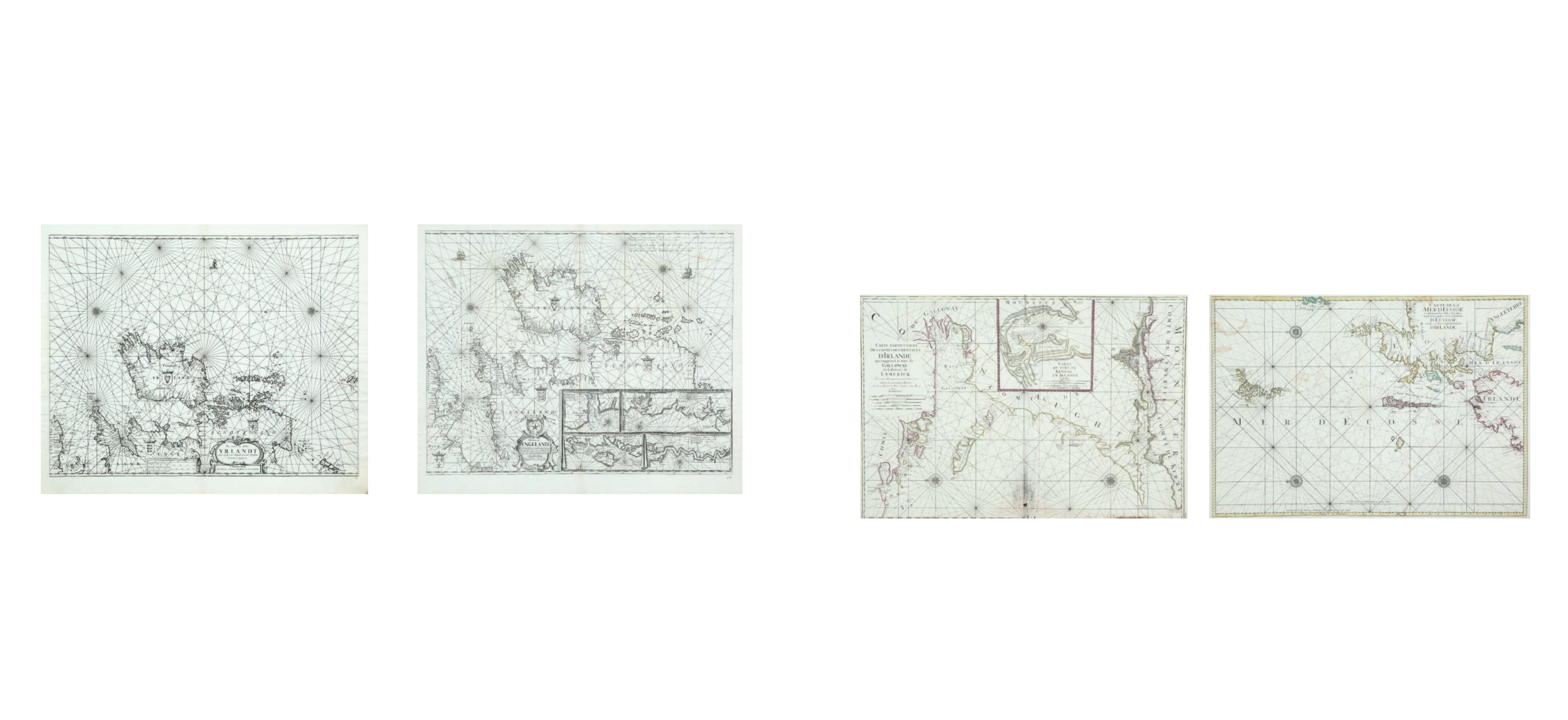
Mortier, Pieter III
Chart of Galway Bay and the Shannon Estuary
(865 x 595 mm)
This chart is from Le Neptune Francois, published by Pieter Mortier and Hubert Jaillot in
Amsterdam in 1693.
“Carte Particuliere Des Costes Occidentales D’Irlande Qui comprend la Baye de Galloway Et
la Riviere de Lymerick. Comme elles paroissent a basse mer dans les grands Marees. Levee
et Gravee Par Ordre du Roy. A Paris. 1693.” Below this are the scales “Echelles Lieues de
France et d’Angleterre a 20 par degre 4 [= 146 mm.] Lieues d’Allemagne a 15 par degre 3 [=
146 mm.] Lieues d’Espagne a 17 1/2 par degre 3 [= 127 mm.] Milles d’Irlande 8 [= 122 mm.]
Toises 1000 [= 128 mm.]”.
“Echelles Mille d’Irlande 1 [= 134 mm.] Mille d’Angleterre 1 [= 108 mm.] Toises 1000 [= 104
mm.] Quart de Lieue de France a 20 par degre 1 [= 82 mm.]”.
€ 250 - 350
50
Mortier, Pieter (1661-1711)
A Chart of Northern Ireland and Scotland (1693)
“Carte de la Mer d`Ecosse Contenant les Isles et Costes Septentrionales et Occidentales
d`Ecosse et les Costes Septentrionales d`Irlande.”
From Le Neptune Francois (1693). The title is the same as on Pene`s chart and differences
are small, but the clearest is that in this version the apostrophe of “D`ECOSSE” in the
centre is 3 mm long and fatter, compared with a slender 6 mm in Pene`s edition. Verso
blank. 860 x 590.
€ 250 - 350
Pieter Mortier II, bookseller and printer, was born in 1661, the eldest son of Pieter Mortier I, a weaver of Leiden, and Anna Boot (Koeman, 1967-71). Pieter Mortier I was son of Martijn de Mortier and Lenne de
Lanoy who were refugees from Paris. Pieter Mortier II was born in Leiden, but the family moved to Amsterdam soon after his birth. He probably received his education as a bookseller in Paris, where he lived
from 1681 to c. 1685, before becoming a member of the booksellers’ guild in the latter year, and he was always associated particularly with publication of French books and atlases. His business was “at the
Vijgendam” and expanded to occupy houses No. 8, 9 and 10 as well as other houses in Amsterdam. He married in 1694 Amelia ‘s Gravensande (c. 1666-1719), who took over the business after his death in 1711.
He had two sons who were not involved in the business and one Petrus or Pieter III (1704-1754) who had a separate shop in the Kalverstraet. His daughter Agatha Amelia Mortier married in 1721 Johannes Co-
vens I (1722-1794), and he took over the business under the name of Covens and Mortier. They had a son Johannes Covens II (1722-1794) who ran the firm under the name of J. Covens and Son after his father’s
death. Their son was Cornelis Covens (1764-1825) and his was Cornelis Johannes Covens (1806-1880), and in this period it became again associated with the Mortier family, this time Pierre or Pieter Mortier V,
grandson of Pieter III, as Mortier, Covens and Son.
Pieter Mortier’s first privilegio was in 1690 for re-printing the maps of Sanson but he immediately went into partnership with Marc Huguetan, another immigrant from France. They published,
between 1696 and 1708 a copy of Jaillot’s Atlas Nouveau, with a large map of Ireland entitled “Le Royaume d’Irlande diuise en ses Quatre Provinces ....”. There was also an Atlas Portatif (? 1700), a war atlas Les
Forces d’Europe (1702), an Atlas Antiquus (1705) and Townbooks of Italy (1704-5), a re-issue of Joan Blaeu’s plates. Covens and Mortier continued the family tradition of using other cartographers’ maps by
publishing Allard’s map of Ireland (“Hyberniae Regni ....”) under their imprint c. 1730.
In 1693 Pieter Mortier collaborated with Hubert Jaillot of Paris to copy and re-issue Le Neptune Francois (De Fransche Neptunus), and in spite of the statement on the title page this version was
engraved and printed in Amsterdam. In fact, the phrase “Levee et gravee par ordre du Roy” on several of the charts was only added to help the atlas to sell, though of course it is not on the original charts.
Their success can be judged by the fact that there are four times as many of their Neptune Francois in the libraries of Europe as of the original version. As well as the above additions, the original engravers’
names were omitted from the charts and the watermark on the paper is different. The original Pene edition uses paper with a two-headed swan and the name “BYCOLOMBIER” (see Lister, 1965, p. 94, no. 147).
The Mortier-Jaillot editions use paper either with no watermark or with a monogram of the letters “ILP” superimposed (see Lister, 1965, p. 93, no. 117). It is not known what the initials stand for or why only
some sheets have it. There were editions in 1693 with French, Dutch and English text, and there was also an Atlas Maritime, not based on a French prototype at all, but with new charts engraved by Romein de
Hooghe. This edition was followed by a Suite du Neptune Francois of 1700 and a new edition of the main volume with French text only, in 1703. Mortier and Jaillot’s Neptune Francois has three Irish charts, as in
the version listed under Pene.
48
Jan van Loon (c.1620-1686)
A Chart of Ireland and England with Insets of Harbours
“Pascaerte van Engeland, Schotland, Yerlant en een gedeelte van Franckryk, alles op syn
behoorlycke cours veerheyt en breete geleyt, medewat diepte, droogte en ancker gront men
op jder plaets heeft, int licht gebracht. t`Amsterdam, Door Iohannes van Loon, Plaetsnyder
en Zee-caert-maecker.”
This is the eighth chart in the Klaer Lichtende Noort-Ster Ofte Zee-Atlas (1661), and the
second state with the additional number “8” in the lower right corner. It also has four
rectangular insets of harbours in France and England in the lower right quarter. 540 x 435.
€ 200 - 400
47
Jan van Loon (c.1620-1686)
A Chart of Ireland and the Irish Sea (1661)
Mathematician, writer and engraver of Amsterdam, was involved in several map publish-
ing projects, but little is known about his life. He published his Klaer Lichtende Noort-Ster
Ofte Zee-Atlas in 1661, with two charts of Ireland and the Irish Sea, and incomplete cover
of England and Scotland.
“Pas-caarte om Achter Yrlandt om te zeylen, van Hitland tot aen Heyssant. Nieuwlycx utge-
geven. “ And separately. “t`Amsterdam, by Iohannes van Loon, Plaetsnyder en Zee-caert-
maker.”
From the Klaer Lichtende Noort-Ster Ofte Zee-Atlas (1661), and the second state with the
additional number “3” in the lower right corner It is a close copy of a chart by Doncker.
535 x 425.
€ 200 - 400
Jan (or Johannes) van Loon was a mathematician, writer and engraver who worked for various Amsterdam booksellers, but little on his own. Details of his origins and home life are scant, con-
sidering his bibliographical importance and the length of his working life. He wrote the text for the English edition of Theunis Jacobsz’s Zee-Spiegel, which was published in 1643 (and presumably for the
other editions). He also contributed to the pilot-books of Doncker (Voorlooper des Zee-quadrants ofte Ruitkaert, 1651), Janssonius (Le Nouveau Flambeau de la Mer, 1650; De Lichtende Columne, 1651-52;
The Lighting Columne, 1654), van Keulen (Zee-Fakkel, 1681) and Robijn (Brandende Veen, 1685). Jan van Loon died in 1686.
Jan van Loon’s first venture at his own risk was the Klaer Lichtende Noort-Ster Ofte Zee Atlas, published in Amsterdam in 1661 with 35 charts. The plates were sold to Johannes Janssonius van
Waesberghe in 1666, who enlarged the atlas to 47 charts, but Jan and Gilles van Loon continued to sell the Zee-Atlas from their shops in Amsterdam. Janssonius van Waesberghe published the atlas under
his name until 1706, but only nine editions (all in Dutch) were produced between 1661 and 1706.
Several of van Loon’s charts were also used by Casparus Lootsman in the Zee-Atlas or Zee-Spiegel between 1666 and 1705, including one of the Irish charts (II), which appears in the Zee-Spie-
gel of 1705 attributed to Casparus Lootsman and his nephew J. Coynenberg.
Gilles van Loon may have been a brother of Jan, but it is not known whether the “H. van Loon”, engraver of charts in the Neptune Francois was related.
Loon, Jan van (c.1620-1686)
Mortier, Pieter (1661-1711)