


 32-33 / 160

33
The R.S.J.Clarke Collection of Cartography
15
th
December 2015
58
Jacques Nicolas Bellin (1703-1772)
A Chart of Scotland and the Northern Coast of Ireland
“Carte Reduite des Isles Britanniques Troisieme Feuille. Partie Meridionale de l`Ecosse …..”,
With rhumb lines but no “Depot de la Marine” mark. (1757).
870 x 550.
€ 150 - 250
57
Bellin, Jacques Nicolas (1703-1772)
A Chart of the Irish Sea and the East Coast of Ireland
“Carte Reduite des Isles Britanniques. Seconde Feuille. Partie
Septentrionale de l`Angleterre …..”,
With rhumb lines but no “Depot de la Marine” mark. (1757).
870 x 550.
€ 150 - 250
Jacques Nicolas Bellin was born in Paris in 1703 and became a hydrographer in the
French Depot de la Marine. He produced maps for Charlevoix’s Nouvelle France in 1744 and an
Atlas to accompany Prevost’s Histoire des Voyages from 1738 to 1775.
His first important publication was a new edition of Le Neptune Francois, which had
originally been published in 1693, edited by Charles Pene. By 1751, when the French navy decided
that a new edition was required. The original plates had become dispersed. However, all but two
were acquired and the latter were now replaced, multiple scales of longitude being added to all.
The original reference point had been Les Isles de Fer, but scales for Paris (observatory), Tenerife,
London (St. Paul’s Cathedral) and the Lizard were added. The whole was published in 1753 with a
preface describing the history of the work. The three Irish charts were unchanged from Pene’s edi-
tion, except that chart III of Galway and Limerick is a new plate, though a very close copy including
the original engraver’s signature (C.A. Berey).
In 1757 Bellin produced 5 new charts of the British Isles, covering South England, North
England, South Scotland, North Scotland and Ireland. They have been brought up to date and most
have attractive title cartouches in the style of the period. All but the sheet of the north of Scotland
also contains part of Ireland, so for the sake of completeness all have been described here. These
charts were produced essentially for the Hydrographie Francoise, a collection of charts of the whole
world, but with European charts in Volume I. It was published over the period 1756-1765 and con-
tinued in production, with alterations, until c. 1800.The charts were also added to later editions of Le
Neptune Francois.
Some time after the first edition of the British Isles series, perhaps about 1773, a circu-
lar mark with “Depot de la Marine” and a price were added. The price at first read “Prix trente Sols”
but after the Revolution (1789) rose to “Prix cinquante Sols”. At this latter stage the fleur-de-lis in
the compass rose was also replaced by the cap of liberty, and those in the circular mark were either
omitted or replaced by “R.F.”. However, the atlases of the period are mixed in their map types, and
even include a Mortier-Jaillot chart (not Irish).
Jacques Nicolas Bellin also produced in 1757 his Essai Geographique sur les Isles Britan-
niques, contenant une Description de l’Angleterre, l’Ecosse et l’Irlande .... Par M. Bellin, Ingenieur de
la Marine et du Depost des Plans, Censeur Royale de l’Academie de Marine et de la Societe Royale
de Londres. MDCCVII. It is a quarto volume and, as the title indicates, it is firstly a description of
the country, while a second part contains sailing directions and the third part is an account of the
five-sheet series of the British Isles. The maps in the volume include one general maps of Ireland
and four small seaport plans or charts. There is also a “Veue de Carreck-fergus” on p. 173 (58 x 120
mm.) showing the castle with two ships in front and the town behind, with the imprint below “J. de la
Croix Sculp.”
A second edition of this work appeared in 1759, but it was in two duodecimo volumes
entitled Essai Geographique sur les Isles Britanniques Premiere Partie, Contenant une Description
de l’Angleterre, de l’Ecosse et d’Irlande and Seconde Partie, Contenant le Portuland ou Routier des
Costes d’Angleterre, d’Ecosse et d’Irlande .... both Par M. Bellin, Ingenieure de la Marine .... Paris
.... MDCCLIX. There is one Irish map/chart in Vol. I and a small chart of Kinsale in Vol. II, which are
identical with maps/charts in the 1757 edition.
In 1757 Bellin also produced a French edition of Greenvile Collins’ Great Britain’s Coast-
ing Pilot, using the 1723 edition charts as a basis. It was entitled Cartes et Plans de Plusiers Parties
Des Cotes D’Angleterre, D’Ecosse et D’Irlande copie sur celles du Pilote Cotier de la Grande Bretagne
de Greenville-Collins. There is no decorative title-page, but only this description and a list of charts I
- XIX, with a note on his Essai Geographique and the date. The charts are smaller than in the English
editions, with the dedication and the decorative detail omitted, but they are very finely engraved.
There are no charts of Dublin Bay or Carlingford Lough.
Bellin produced in 1764 the Petit Atlas Maritime, of quarto size, in five volumes, with
new finely-drawn maps and charts covering the whole world. It contains four Irish maps in Volume
IV, of Ireland, Dublin, Kinsale and Galway. He published finally an Atlas de Corse in 1769 and died at
Versailles on 21st March 1772.
56
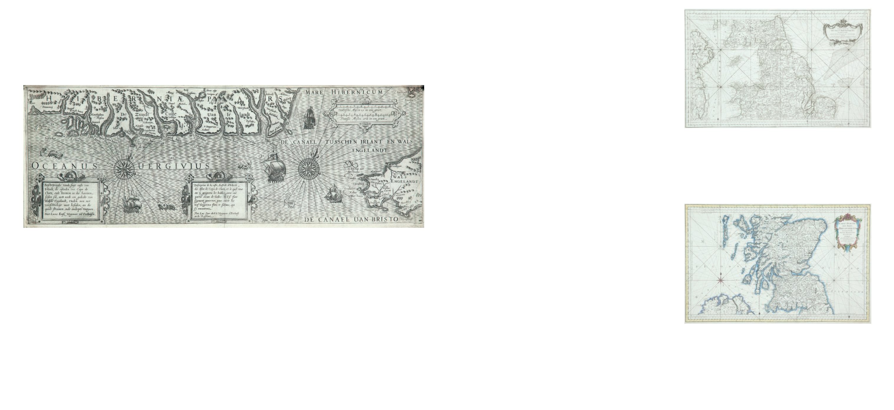
Lucas Janszoon Waghenaer (1533-1606)
A Chart of the South Coast of Ireland (1601)
“Description de la Coste Australe d`Irlande, des Isles de Capo de Claro et a vent on y gaign-
era les hables avec une partie encore de Galles ou il se sant sagement gouverner pour eviter
les tres dangereux flots et sablons, qui s`y renccontrent. Par Luc Iean dict le Waghenare
d`Enchuse et la Resident.”
It also has the words “Josua van den Ende fecit” unlike an earlier version. It has the page
number “12” in the top right. From the Thresoor der Zeevert (1601).
Verso blank. 535 x 190.
€ 2,000 - 4,000
Bellin, Jacques Nicolas (1703-1772)
French Charts