


 30-31 / 160

31
The R.S.J.Clarke Collection of Cartography
15
th
December 2015
55
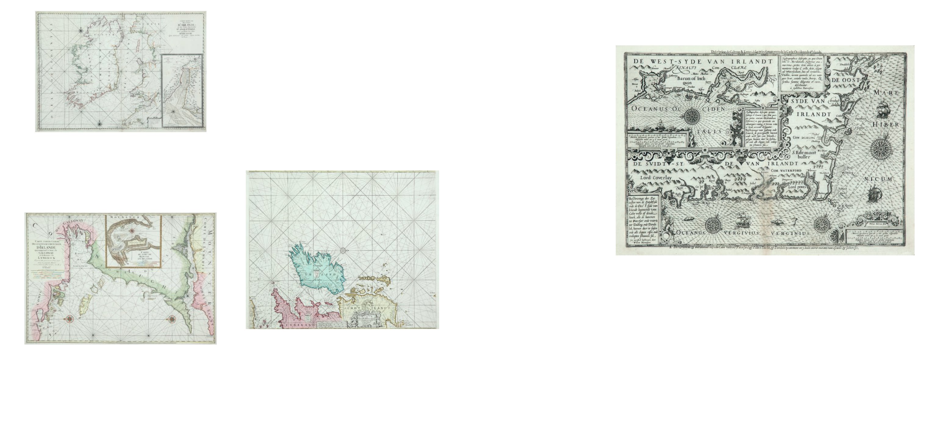
Waghenaer, Lucas Janszoon (1533-1606)
A Chart of the East and South of Ireland with Insert of Galway
“Hydrographica descriptio, in qua Orientales et Meridionales Hyberniae orae maritimae, portus item omnes a promontorio vulgo C. Vello dicto usque ad Waterfordiam hinc ad
civitatem Dublin, necnon quomodo ad eas navigare liceat, evitatis vadis, brevijs, & syntibus summa diligentia et cura, describuntur a Guilielmo Barentsono”,
with the same title in Dutch. It is from the 1600 (French) edition of Den Nieuwen Spiegel der Zeevaert with a further French title above the frame of the chart “Description
de Galway & Lemrick les principaux portes de la Coste Occidentale d`Irlande.” There is a large inset of Galway Bay and the Shannon estuary. There are two pages of text
on the verso, and in the middle of the left hand page is the marvellous statement “Il y a de toutes sortes de Tigres mais ils sont si gras qu`ils ne peuvent point courir si
vitement que sont ceux qu`on trouvent en d`autres pays.” 500 x 345.
Ship`s pilot and later publisher, particularly of two great guides to navigation, Der Spiegel der Zeevaert (1584), enlarged with an Irish chart as Den Nieuwen Spiegel der
Zeevaert (1596). In the interval he had brought out his Thresoor der Zeevaert in 1592.
€ 2,000 - 4,000
Lucas Janszoon Waghenaer was born at Enkhuizen in
1533/34. It was a prosperous town, with 160 boats in 1550,
engaged in fishing, smuggling and piracy. It was one of the
first to declare for William against Spain. Lucas Waghenaer
became a ship’s pilot and acquired a wide knowledge of
the northern waters of Europe. He published his first map,
which was of Amsterdam, in 1577 and obtained a post in the
town as “receiver of licence and convoy moneys” in 1579. He
then spent the rest of his life producing his two great guides
to navigation. Both consist mainly of sailing directions with a
relatively small number of charts. These were the first print-
ed charts to give regular soundings at half-tide and adopted
the practise of showing harbours on a larger scale than the
rest of the coast-line.
Der Spiegel der Zeevaert was printed in Dutch
by Christopher Plantin of Leyden in 1584. It is a beautifully
produced folio volume of two parts in one, with the charts
coloured in the earlier editions. The first Latin edition came
out in 1586 and the English edition or Mariner’s Mirrour,
translated by Anthony Ashley and printed in London,
appeared in 1588. None of these had an Irish chart, which
was only introduced in Den Nieuwen Spieghel der Zeevaert
van de Navigatie der Westersche Zee, based on that in the
Thresoor. This volume has two pages of text relating to Ire-
land and a chart drawn by Willem Barentsoon and engraved
by Pieter van den Keere. This enlarged Spieghel was pub-
lished in Amsterdam with a second Dutch edition in 1597,
French editions in 1600 and 1605 (Le Nouveau Miroir des
Voiages Marins de la Navigation). A further enlarged edition,
Den Groten Dobbelden Nieuwen Spieghel der Zeevaert, was
brought out in 1603. There are four pages of text describing
Ireland, the last two of which are on the verso of both pages
of the Irish chart, which varies from edition to edition.
Waghenaer brought out his Thresoor der
Zeevaert in Leyden in 1592. It is in oblong folio and, being a
simpler production altogether, was more useful at sea (and
is therefore scarcer now). There are detailed sailing directions, including three pages of text on Ireland with five coastal profiles of the area. There were Dutch editions in 1596, 1598, 1602, 1606, 1608 and 1609, as well as
French editions (Thresorie ou Cabinet de la Routte Marinesque) in 1601 and 1606. These charts have titles in Dutch and French for greater utility, rather than the Dutch and Latin used in Der Spieghel der Zeevaert. Dating
from 1592, the Irish chart is the first printed chart specifically of the Irish coast produced by any cartographer.
A second edition of The Mariner’s Mirrour was published in 1605 with the former plates by Jodocus Hondius and a new version of the Irish chart. It was copied closely from that of van den Keere but was also
engraved by Hondius.
54
Robijn, Jacob (1848- c. 1710)
A Chart of Ireland and the Irish Sea
“Paskaerte om Achter Yrland om te Zeylen van d`Orcades tot aen Heysant t`Amsterdam By
Iacob us Robijn. Met Privilegie.”
This is from the Zee-Atlas and in the second state, with the addition of the words “Met
Privilegie”. 595 x 515.
Bookseller and publisher, of Amsterdam, first produced his Zee-Atlas in 1683 and contin-
ued in several languages over many editions and other titles.
€ 200 - 300
Jacob Robijn was born in 1648/49 and was described on 15th December 1673
as an orphan (Koeman, 1970). At that time he was an illuminator of maps, living in the
Nieuwebrugsteeg, Amsterdam, and became betrothed to Jannetje Tol of Marken. In the
following year he became a member of the booksellers’ guild and was soon competing
with Doncker, Goos and the Jacobsz family as a chartseller. After a short association with
Johannes van Keulen in 1679, he bought the plates and rights of the Zee-Spiegel and
Zee-Atlas from Pieter Goos’s widow, and published editions of these works from 1680
onwards. In them he sometimes used the plates unchanged, as in the N.M.M. edition of
1683, and sometimes added his own name to the plates. He also produced some new
plates in 1683, such as the Irish chart I below. However, on the whole he was mainly a
bookseller and published of chart-books such as Het Brandende Veen of Arent Roggeveen.
The latest date known for his shop is 1707 and he probably died in the next few years -
certainly before 1717.
Robijn’s Zee Atlas was first published, with Dutch text, in 1683 in Amsterdam,
and has the usual “Paskaerte om Achter Yrland” closely resembling those of Doncker, Goos
and Jacobsz, though actually a new plate. Further editions of the Zee Atlas continued to
appear in Dutch, English, French and Spanish until 1696. The Nieuwe Groote Zee-Spiegel
produced by Roggeveen, and in 1694 by Robijn in the usual five parts, contains Irish charts
in Part II which are simply those of Jacobsz, and are listed under his name. Likewise in
Robijn’s Sea Mirrour any Irish charts are really those of Jacobsz/Goos.
52
Pieter Mortier (1661-1711)
A Chart of the West Coast of Ireland with an Insert of
Kinsale
“Carte Particuliere des Costes Occidentales d`Irlande qui comprend la Baye de Galloway et
la Riviere de Lymerick. Comme elles paroissent a basse mer dans les grands Marees. Levee
et Gravee Par Ordre du Roy. A Paris. 1693”
From Le Neptune Francois (1693). The title has the additional and misleading phrase at
the end, and the engraver`s name in the lower left corner is absent, compared to the
Pene version. Verso blank. 865 x 595.
€ 250 - 350
51
Pieter Mortier (1661-1711)
A Chart of Ireland and the Irish Sea with an Insert of the River Dee
(1693)
“Carte Generale des Costes d`Irlande et des Costes Occidentales d`Angleterre avec une
Partie de celles d`Ecosse. Levee et Gravee Par Ordre Exprez du Roy. A Paris.”
From Le Neptune Francois (1693). The title has the additional and misleading phrase
at the end, and the engraver`s name in the lower left corner is absent, compared to
the Pene version. Many copies also have the date “1693” at the end of the title. Verso
blank. 850 x 590.
€ 250 - 350
Waghenaer, Lucas Janszoon (1533-1606)
Robijn, Jacob (1848- c. 1710)