


 18-19 / 160

19
The R.S.J.Clarke Collection of Cartography
15
th
December 2015
22
Theunis Jacobsz (1606-1650)
A Set of Four Charts of Ireland and the Irish Sea (1667), including
South-east, North-east, North-west and Southwest
(i) “De Zuyd oost zyde van Yerlandt Van Dubling tot aen
t`Eylandt Corkbeg. T`Amsterdam. By Iacob Theunisz op t`
water inde Loots-man.”; (ii) “De Noord-oost zyde van
Yerlandt van Caap de Hoorn tot aen Hedehde en Als mede
hoe`t`van Schotlandt gelegen is. `t Amsterdam. By Theunis
Theunisz. Op`t water in de Lootsman.”; (iii) “De Noordwest
zyde van Yerlandt Beginninde van Capo de Hoorn tot aen
Schynrs, of Slyne-head. T Amsterdam. By Iacob Theunisz
op`t water inde Loots-man.”; (iv) “De west custen van
Yerlandt Beginninde van Corckbeg tot aen Slynehooft. `t
Amsterdam. By Iacob Theunisz op`t water inde Lootsman.
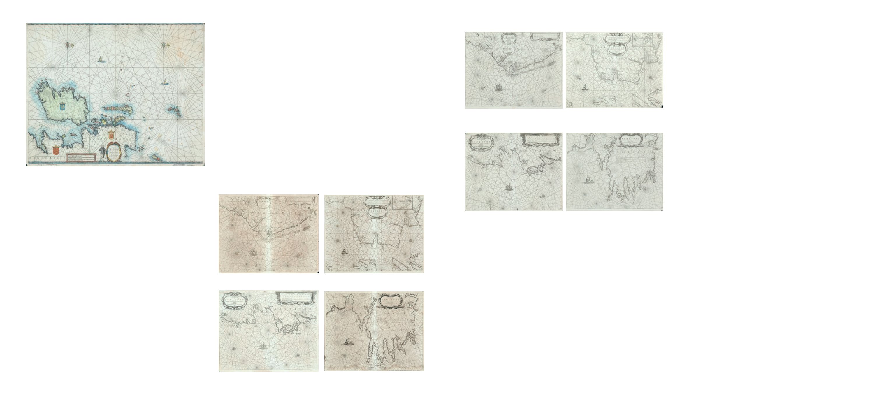
Met Privilegie Voor 15 Iaren.”
Set of four charts of the Irish coast from the Nieue en Groot Loots-mans Zee-Spiegel of
1696. They have numbers “W 14” to “W 17” in the lower
right corner and verso blank. All have the words “Met
Privilegie Voor 15 Iaren” added, but in the first three it is in
the lower right corner, whereas in the fourth it is at the end
of the title. 530 x 430. (4)
€ 1,000 - 1,500
Joannes Janssonius (Jan Jansson) was born at Arnhem in 1588, the son of Joannes
Janssonius, bookseller and publisher of Arnhem. The father published many geographical books,
including the editions of the Mercator-Hondius Atlas Minor between 1607 and 1621. Joannes, the
son, married in 1612 Elizabeth Hondius, daughter of Joducus Hondius of Amsterdam, and by her
had 2 sons and 5 daughters. Elizabeth died in 1627 and two years later Joannes married secondly
Elizabeth Carlier of Cologne. He died in 1664 and was buried in the Westerkerk at Amsterdam and,
since his sons had died, the business passed to his daughter’s husband Joannes van Waesbergen,
who took the additional name of Janssonius. He allowed the business gradually to decline, most
of the plates, stock, etc. being sold in 1676 and he died in 1681.
In 1620 Joannes Janssonius of Amsterdam produced his version of Blaeu’s Het Licht
der Zeevaert, since the latter’s privilege had expired in 1618. This was followed by five Dutch
editions in 1620-34, English editions in 1620 and 1625 (The Light of Navigation), and a French
edition in 1620 (Le Flambeau de la Navigation). These contain his copy of Blaeu’s Chart of the
South-East Coast of Ireland, which follows the same outline geographically, though it differs in title
and decorative detail.
Jansonius published an enlarged edition of the atlas in 1634 under the name of Het
nieuw Vermeerde Licht .....des Grooten Zee-Vaerts. The text was enlarged by Joris Carolus and
19 new charts were added including 5 of Ireland, which replaced those of Blaeu/Jansson (15-19
in the second volume). The charts were probably modified from Blaeu’s Zeespiegel charts. Joris
Carolus was a pilot from Enkhuysen who, after serving as a pilot from 1614, settled in Amsterdam
about 1625 as an instructor. Many of the new charts have Carolus’ signature, though not those
of Ireland. This pilot-guide, with its five Irish charts, appeared in French editions in 1635 and 1637
under the title of Le Nouveau Phalot de la Mer.
There is a particularly confusing item in the British Library entitled Het Licht der Zee-
vaert ..... Door Willem Ians Zoon, Amsterdam, 1632. It has also an English language title-page with
“The Light of Navigation ..... By William Iohnson, .... Amsterdam .... 1625”, pasted over the Dutch.
In fact, some of the charts are dated as late as 1641 and it contains the five Carolus charts.
In 1650 Janssonius published Le Nouveau Flambeau de la Mer which, according to
Koeman probably had originally the same charts as the 1620 Flambeau de la Navigation, but in
the only surviving copy (in Rotterdam) has lost most of its charts including the Irish one.
At the same time Janssonius was collaborating with Theunis Jacobsz, and in 1651
brought out De Lichtende Columne ofte Zee-Spiegel. It is essentially identical with the Goos 1650
Lichtende Columne, which contains the four Irish charts produced by and listed under Jacobsz. He
published another edition of the same atlas in 1654, with van Loon’s name as author on the title
page.
Janssonius had been even more involved as published in the production of the Mer-
cator-Hondius Atlas since the death of Joducus Hondius II in 1629, and in 1636 he produced his
own maps of Ireland and the four provinces for the first time. There were included in some issues
of the Mercator-Hondius Atlas, but regularly in Volume IV of his Atlas Novus which appeared from
1638-59 in Latin, Dutch, French, German and Spanish editions. After the sale of 1681 the plates
passed into the hands of Visscher (c. 1690), and c. 1730 to Schenk and Valk, who re-issued them
after much alteration.
In 1650 Janssonius produced a fifth volume of the Atlas Novus, which Koeman
describes as the first sea-atlas, in the sense of having folio-sized charts covering the whole world.
Sometimes this chart volume is known as Volume VI. It was followed by the sea atlases of most of
the main marine cartographers : Doncker (1659), van Loon (1661), Colom (1663), Goos (1666) and
Lootsman (1666). It appeared with Latin text in 1650, 1652, 1657, 1659; with Dutch text in 1650,
1652 and 1659; with French text in 1650, 1652 and 1657; and with German text in 1650, 1652 and
1657. The long text accompanying the charts includes 5 1/2 pages on Ireland. The Irish chart is
a copy of that in Jacobsz’s Zee-Spiegel (1643) and could be regarded as a chart of the British Isles,
except for the fact that the title cartouche obscures East Anglia. It usually has text on the back
and the editions can be distinguished by the language as well as by changes in the type-setting.
20
Theunis Jacobsz (1606-1650)
A Chart of Ireland and the Irish Sea (1688)
“Pascaerte om achter Yrlandt om to zeylen van Hitland tot
aen Heysant; Nieuw lycx uytgegeven `t Amsterdam by
Theunis Jacobsz op t`water inde Lootsman.”
From the
Nieuwe Water-Werelt Ofte Zee-Atlas of Jacob “Lootsman”,
later state of 1688. Changes have been made to some of the
islands and the words “Met Privilegie voor 15 Iaren” have
been added. Verso blank. 540 x 440.
€ 250 - 350
21
Theunis Jacobsz (1606-1650)
A Set of Four Charts of Ireland and the Irish Sea (1667), including
South-east, North-east, North-west and Southwest
(i) “De Zuyd oost zyde van Yerlandt Van Dubling tot aen
t`Eylandt Corkbeg. T`Amsterdam. By Iacob Theunisz op t`
water inde Loots-man.”; (ii) “De Noord-oost zyde van
Yerlandt van Caap de Hoorn tot aen Hedehde en Als mede
hoe`t`van Schotlandt gelegen is. `t Amsterdam. By Theunis
Theunisz. Op`t water in de Lootsman.”; (iii) “De Noordwest
zyde van Yerlandt Beginninde van Capo de Hoorn tot aen
Schynrs, of Slyne-head. T Amsterdam. By Iacob Theunisz
op`t water inde Loots-man.”; (iv) “De west custen van
Yerlandt Beginninde van Corckbeg tot aen Slynehooft. `t
Amsterdam. By Iacob Theunisz op`t water inde Lootsman.”
Set of four charts of the Irish coast from the Nieue en Groot
Loots-mans Zee-Spiegel of 1667. They have numbers “W
14” to “W 17” in the lower right corner and verso blank.
530 x 430. (4)
€ 1,000 - 1,500
Janssonius, Johannes (1588-1664)