


 14-15 / 160

15
The R.S.J.Clarke Collection of Cartography
15
th
December 2015
13
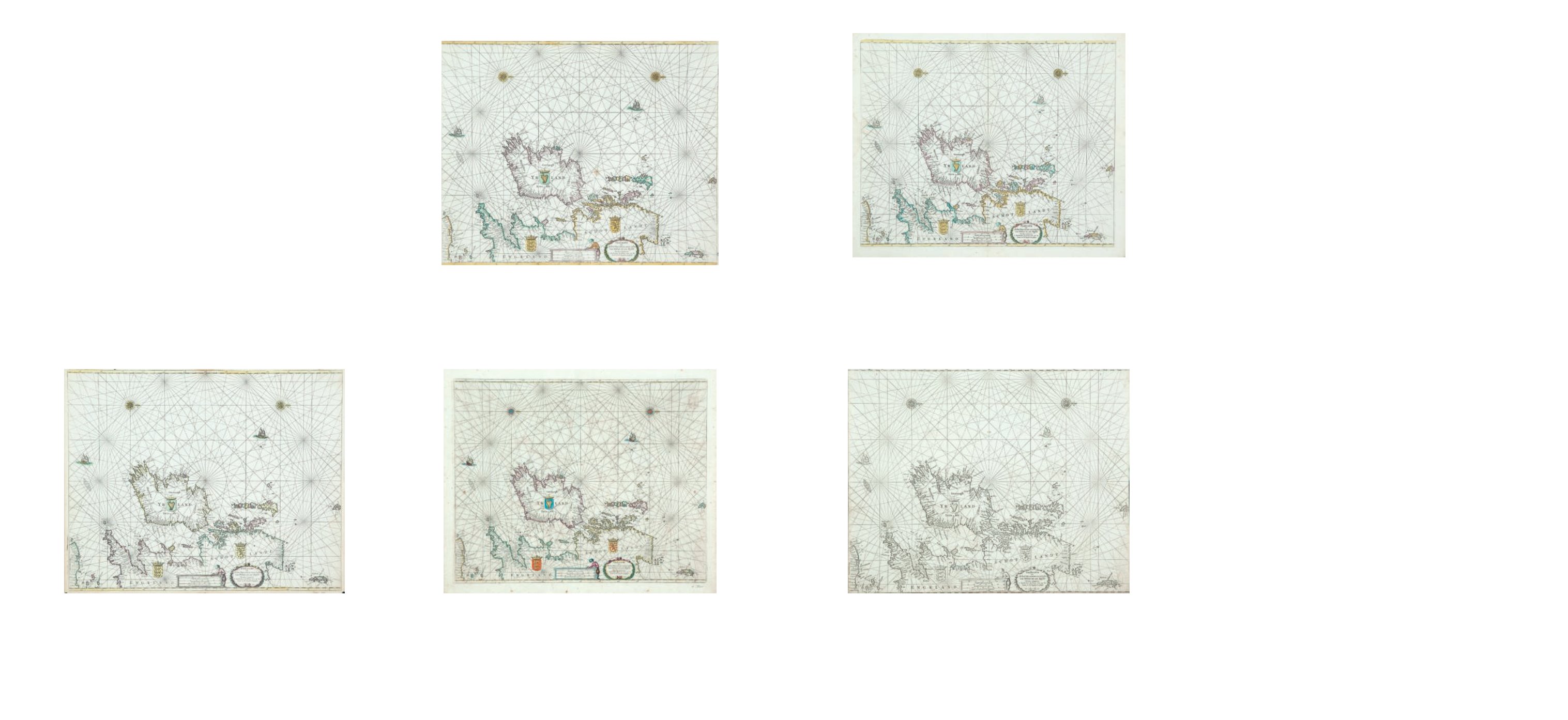
Pieter Goos (1615-1675)
A Chart of Ireland and the Irish Sea (1669)
“Paskaarte om Achter Yrlandt om te Zeijlen van Hitland tot
aen Heijsat Nieuwlycx Utgegeven
t`Amsterdam bij Pieter
Goos op het waater in De Verguide-Zee-Spiegel. Anno
1669.” (1669). Verso blank.
550 x 445.
€ 250 - 350
Theunis or Anthonie Jacobsz. was born in 1606/7 and was the founder of a
printing and publishing house in Amsterdam. As there was more than one printer of the
neame he added the adjective “Lootsman” or pilot, to his. He married in 1631 Lijntje Robi-
jns and had 5 children. He died in 1650 leaving them under age, so that his widow ran the
business until the two boys, Casparus (1635-1711) and Jacob (d. 1679) should come of age.
Jacob died fairly young and Caspar later joined up with his nephew Jacob Conijngsberg
(1675 - c. 1710), son of his sister Jannetje.
The first publication of Theunis Jacobsz was his De Lichtende Columne ofte
Zee-Spiegel published in Amsterdam in English in 1643. It takes the usual form of pi-
lot-guide (21 pages) with charts which appear to have been newly engraved by him. There
were many editions in Dutch between 1644 and 1717, as well as editions in French, Le
Grand & Nouveau Miroir ou Flambeau de la Mer (1666 - 1697) and English, The Lightning
Column or Sea Mirrour (1643 - 1692). In the first (English) edition the author of the text is
given as Iohn van Loon while Theunis Jacobsz is described as the printer, though it appears
that he was responsible for the charts. From the outset Jacobsz probably envisaged
cooperation with Pieter Goos in a joint venture, and for this reason left his own name off
the plates. There was also no “Privilege” in the early editions. When Theunis Jacobsz died
in 1650 the plates were transferred to Pieter Goos who continued to print from them (said
by Koeman to be cut down by 2 cm. but this is not true for the Irish charts).
The Zee-Spiegel, Part 2, contains a chart covering most of the British Isles (35)
and four regional Irish charts (41-44). The first of these is described below as of Ireland
and the Irish Sea since it has a large title cartouche obscuring East Anglia. It is oriented
with west to the top and has a scale of latitude above and below but the regional charts
have no scales of latitude or longitude, as was the general practise. This chart was later
modified by moving the cartouche to the bottom right corner, so that it covers the whole
British Isles.
Pieter Goos brought out his Zee-Spiegel in 1650 and the charts are included
below with the Jacobsz series, though the chart books as a whole are tabulated also with
the article on Goos. Johannes Janssonius, who presumably printed the text for Goos, sold
copies of Goos’s Zee-Spiegel under his own imprint while van Loon was again credited with
the text of the English edition (1654). Hendrick Doncker in 1655 issued the whole atlas as
his own Zee-Spiegel. Jacob Robijn finally bought the old plates from Goos’s widow in 1680
and re-used them unchanged, though with his name on the title page (Rob 15). These
other groups will also be described with the charts of Jacobsz, since they are indistin-
guishable. Doncker also copied the Jacobsz plates fairly closely for his own Nieuw Groot
Steuermans Zee-Spiegel which was first published in 1664, with new editions up to 1703.
After the death of Theunis Jacobsz his widow and son produced a complete
pilot-guide in reduced form, which filled the gap caused by the loss of the plates to Pieter
Goos. The smaller pilot guide was entitled t’Nieuwe en Vergroote Zee Boeck ..... and was
published in 1652, 1653 and 1654, in Dutch only. It has seven charts of Irish waters.
In 1654 the new plates were ready and the large pilot guide was reprinted as
Nieuwe en groote Lootsmans Zee Spiegel ..... appearing in many editions in Dutch, French
and English until 1716. It has the same five Irish charts with different plate numbers (W 8
and W 14 - W 17). In the 1705 and and later editions, charts by van Loon were incorporat-
ed, and the 1705 edition contains his chart II with the Lootsman imprint (listed under van
Loon). The French editions have “Traduict du Flaman en Francois par Paul Yvounet” and in
the B.L. catalogue they may be listed under “Yvounet” or “Lootsman”.
In 1666 Casparus and Jacob Theunisz or Lootsman, published the Nieuwe Wa-
ter-Wereld ofte Zee-Atlas..... It had only 28 charts, many of them from the Zee-Spiegel or
an atlas by J. van Loon. There is only one Irish chart covering all Ireland, which is new but
similar to those in the Zee-Atlas of Doncker (1659) and Goos (1666). There were 4 Dutch
editions (1666, 1676, 1678 and 1681), one French edition (1681) and no less than 8 English
editions (1671, 1677, 1681, 1684, 1685, 1688, 1689 and 1694).
14
Pieter Goos (1615-1675)
A Chart of Ireland and the Irish Sea (1673)
“Paskaarte om Achter Yrlandt om te Zeijlen van Hitland tot
aen Heijsat Nieuwlycx Utgegeven t`Amsterdam bij Pieter
Goos op het waater in De Verguide-Zee-Spiegel. Anno
1673.” (1675). Verso blank.
550 x 445.
€ 250 - 350
Pieter Goos was the son of the engraver Abraham Goos of Amsterdam and
was born in 1615/6. He was at first an engraver and later a book-seller and publisher,
living c. 1649 “Op t’Water in de vergulde Zeespiegel” in Amsterdam. He married in 1643
Susanna de Reyger who died in 1648, and secondly in 1649 Geertruyd van Ruyff who
eventually continued running the business when he died in 1675. She died in 1677 and his
son Hendrik Goos (b. 1641) took over, though no new material was produced in his time.
The first publication by Pieter Goos was De Lichtende Columne ofte Zee-Spie-
gel, Parts I and II, which was published in Amsterdam in 1650. However, it was in no sense
original, both plates and text being obtained from Theunis Jacobsz. Goos did not put his
own name on them, so that in the case of most charts it is almost impossible to distinguish
between the source-volumes of isolated items of this period. In spite of the lack of
originality, 17 editions in Dutch, 4 in French (Le Grand & Nouveau Miroir ou Flambeau de
la Mer) and 7 in English (The Lighting Colomne or Sea-Mirrour) came out in the years be-
tween 1650 and 1678. After 1680 the stock and plates of Goos’s Zeespiegel were acquired
by Jacob Robijn, who sold the atlases unaltered under his imprint. The five Irish charts
(numbers 35 and 41-44) are descrbed in detail under Theunis Jacobsz.
In 1666 Pieter Goos produced his De Zee-Atlas Ofte Water-Weereld and it
also was not original, for nearly all the charts (including that of Ireland) were copied from
Herdrik Doncker’s Zee-Atlas. There were 11 editions of this work in Dutch, 5 in French, 5 in
English and 2 in Spanish published between 1666 and 1683. There is one chart of Ireland
and the Irish Sea which, although copied from Doncker, has Pieter Goos’s imprint. John
Seller produced an edition of the Zee-Atlas under the title Atlas Maritimus in 1669/70, with
his own title-page followed by Goos’s charts in the 1669 state. Later Seller engraved his
own plates, which were copied in large part from the Dutch.
10
Pieter Goos (1615-1675)
A Chart of Ireland and the Irish Sea (1663)
“Paskaarte om Achter Yrlandt om te Zeijlen van Hitland tot
aen Heijsat Nieuwlycx Utgegeven t`Amsterdam bij Pieter
Goos
op het waater in De Verguide-Zee-Spiegel. Anno
1663.” (1663). Verso blank. 550 x 445.
€ 250 - 350
11
Pieter Goos (1615-1675)
A Chart of Ireland and the Irish Sea (1666)
“Paskaarte om Achter Yrlandt om te Zeijlen van Hitland tot
aen Heijsat Nieuwlycx Utgegeven
t`Amsterdam bij Pieter
Goos op het waater in De Verguide-Zee-Spiegel. Anno
1666.” (1666). Verso blank. 550 x 445.
€ 250 - 350
Goos, Pieter (1615-1675)
12
Pieter Goos (1615-1675)
A Chart of Ireland and the Irish Sea (1668)
“Paskaarte om Achter Yrlandt om te Zeijlen van Hitland tot aen Heijsat Nieuwlycx Utge-
geven t`Amsterdam bij Pieter Goos op het waater in De Verguide-Zee-Spiegel. Anno
1666.” . (1668). Verso blank.
550 x 445.
€ 250 - 350
Theunis, Jacobsz.(1606-1650)
also known as “Lootsman” (Pilot),