


 150-151 / 160

151
464
Capt. Samuel Hobson
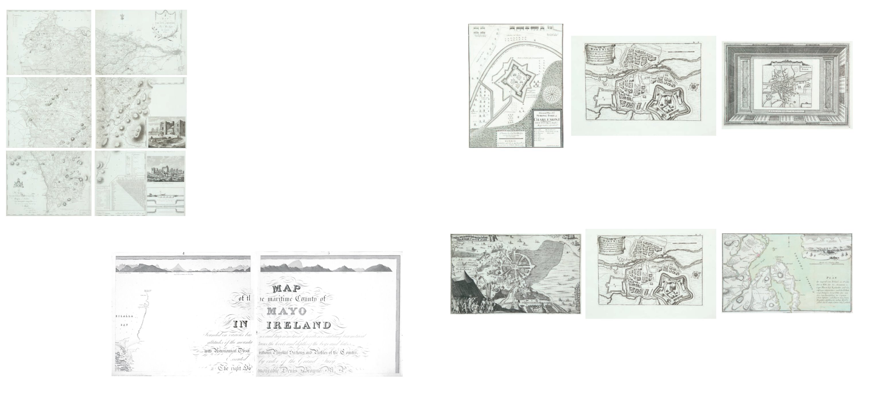
A Plan of Charlemont Fort
Published by Richard Chiswell (1610). 265 x 350.
€ 100 - 200
465
Thomas von Wiering
The Siege of Londonderry
(1689). 180 x 300.
€ 120- 180
466 David de la Feuille (1663-1709)
La ville de Limerik
From his Atlas Portatif. Published in Amsterdam in 1702.
125 x 120.
€ 50 - 70
466 David de la Feuille (1663-1709)
La ville de Limerik
From his Atlas Portatif. Published in Amsterdam in 1702.
125 x 120.
€ 50 - 70
467
Pieter van der Aa
Town Plans of Dublin, Galway, Cork and
Limerick
Three sheets. A Reissue of the Hermannides Plates of 1661.
From La Galerie Agreable du Monde. Published in Leiden
(1729). 325 x 215. Abl 56(ii).
€ 50 - 100
468
Gabriel Nicholas Raspe (1712-1785)
A Map of Belfast Lough
From Schauplatz der Gegenwärtigen Kriege published in
1757. The note refers to Captain Thorot’s landing at Carrick-
fergus in 1760. 360 x 230.
€ 100 - 200
463
Alexander Taylor
A Map of the County of Kildare.
In six sheets. From The Grand Jury Map of the County. 1783.
780 x 590 (each).
€ 1,200 - 1,800
MAYO Map of the maritime County of Mayo in Ireland.
Founded on various bases and trigonometrical operations, exhibiting barometrical altitudes of the mountains, the
levels and depths of the bogs and lakes; with Astronomical Observations, Physical Sections and Profiles of the Country;
Executed by order of the Grand Jury. The Right Honourable Denis Brown M.P. and Member of the Dublin Society,
and Royal Irish Academy, foreman; Commenced in 1809, and terminated in 1817, by William Bald F.R.S.E. Member of
the Royal Geographical Society Paris, Member of the Geological Society London, Member of the Royal Irish Academy,
Honorary Member of the Wernerian Natural History Society Edinburgh. Engraved by Pierre Tardieu, 1830. overall
dimensions when joined - 3.11m x 2.57m. average sheet size 620 x 510
By William Bald, a massively detailed
map of Mayo in 25 sections (), each varying slightly in size; a little detail here and there of adjacent counties. Large
title cartouche. Extensive table of mountain heights. Lake levels; bog levels and depths. Coastal soundings. Plan of
trigonometrical base lines. Scale: 1? inches to 1 mile. Published by the Mayo Grand Jury. Some edges frayed and some
light foxing otherwise in very good condition. William Bald was born in Burntisland in 1789. He was employed as an
apprentice under the celebrated Scottish surveyor, engraver and mapmaker, John Ainslie. Bald made a survey of Harris
in 1805 when he was still only 16, and was later responsible for surveys of Benbecula, South Uist, Eriskey and Argyll,
possibly because the rugged nature of the terrain would have been difficult for Ainslie, then in his 60s. These and other
of his surveys were later incorporated into Aaron Arrowsmith’s map of Scotland.By the time Bald arrived in Mayo in
1809 as county surveyor, he had been described by his teacher and mentor John Ainslie as, ‘’a very big man ...’’ In the
words of John Andrews, ‘’no ordinary tribute for a twenty-year-old.’’Bald’s first commitment in Mayo was a Grand Jury
map of the county. At the same time, he managed to work for the Bogs Commission on their brief for a survey of the
bogs of Ireland. Both surveys were to a degree of sophistication and meticulousness which far outstripped anything
known in Ireland up to that time.His map of Mayo was unique in its scale and scholarship. The base measurement
and triangulation were impeccable. Bald spent 18 years on the Mayo survey and engaged Pierre Tardieu in Paris, the
foremost engraver of his day, to bring the map to fruition. This was done very slowly and at great expense, finally
reaching the light of day in 1830.Bald was a familiar figure in Castlebar, much admired by some, yet disliked by others
who through envy of his greater expertise, carped at his efforts; or who, unused to the sheer cost of mapping on such a
scale, complained at his lavish use of public money.Bald went on to plan surveys of Clare and Down. He even envisaged
a general triangulation of Ireland and a new geological map. He still found time to attend to roads and bridges in his
adopted county.The coming of the Ordnance Survey spelled the end of the era of the great land surveyors, Bald among
them. In later life, he concentrated on roads, bridges, canals and harbours, and eventually railways. He was a principal
adviser in the early deliberations of the Ordnance Survey.William Bald loved Mayo, as can be seen from his Map. The
profusion of placenames, particularly coastal placenames, attests to his love of the Mayo landscape, so like his native
Scotland. He was one of the ablest, most hard-working and most creative map-makers ever to practise in Ireland.He
died in 1857; he is buried in Highgate Cemetery, London. His wife, Anne, pre-deceased him; she is buried in Straide, Co.
Mayo.
€ 3200 - 3800
463A William Bald