


 108-109 / 160

109
www.adams.ieThe R.S.J.Clarke Collection of Cartography
15
th
December 2015
274
William Rogers 1545 - 1604
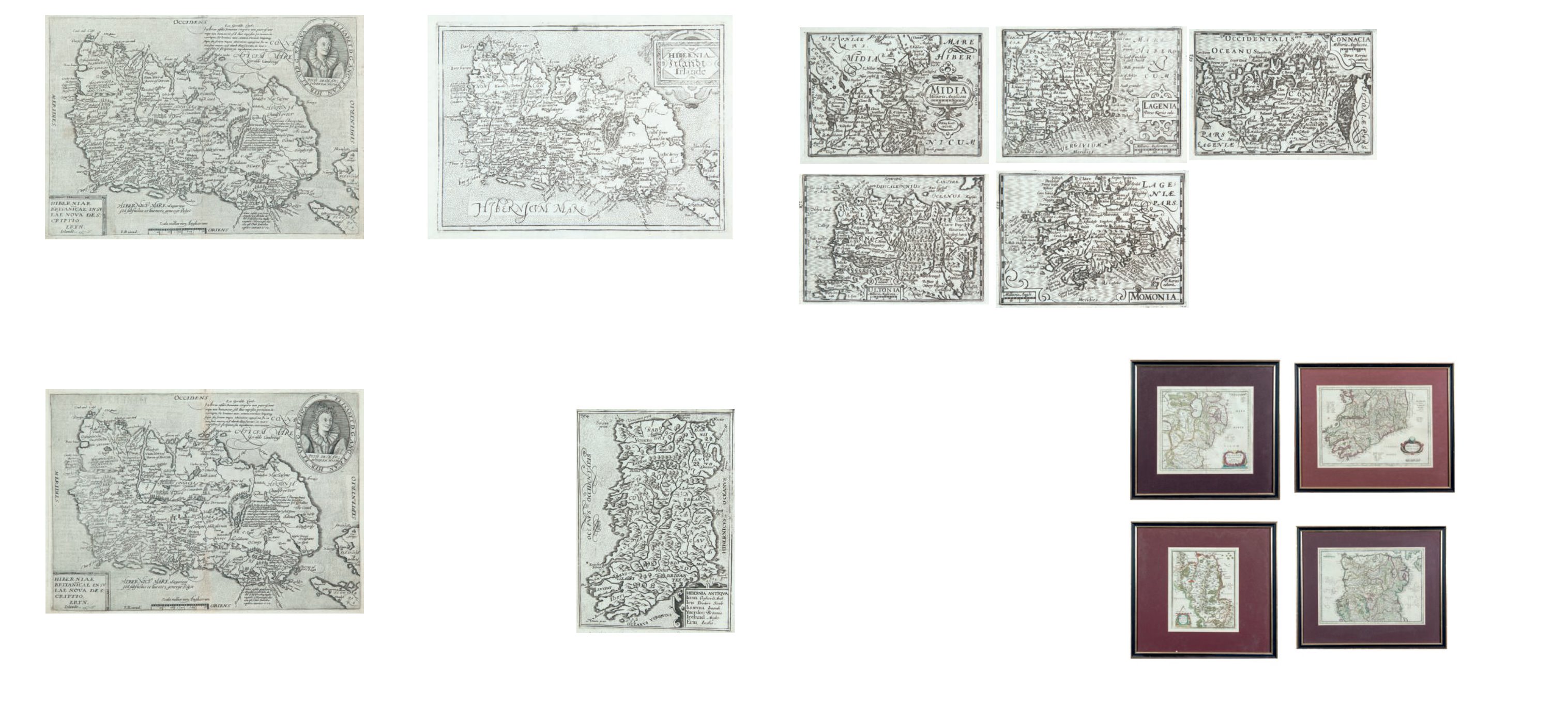
Hibernia Antiqua
From Camden’s Britannia, 5th Edition. The First Illustrated Edition (1600). Latin text. Abl P235.
William Rogers 1545 - 1604
Rogers was an English engraver. A citizen
of London – one of his surviving engrav-
ings is signed Anglus et Civis Lond. – he is
the first English craftsman known to have
practised engraving and the greatest por-
trait engraver of the Tudor period. The
English were extremely late in coming to
printmaking, though several artists from
the thriving Flemish industry had worked
in England already. The engraved print
had been invented over 150 years before
Rogers began to produce them. Rogers
was also a goldsmith, and presumably
acquired his technique in that context.
His portrait style reflects Flemish models,
while his backgrounds are often “over-
loaded with ornament” that is “redolent
of the goldsmith’s shop”. Rogers’ work
shows him to have been a trained artist
in the art of engraving. He is mentioned
by Francis Meres in his Palladis Tamia
(1598): “As Lysippus, Praxiteles, and
Pyrgoteles were excellent engravers, so
have we these engravers: Rogers, Christopher Switzer, and Cure.”
€ 150 - 250
275
John Speed (1552 – 1629)
A Set of Five Maps,
all published
Munster, Leinster, Media, Connaught & Ulster
Engraved by Van den Keer and Published by Blaeu in his Epitome of Camden’s Brittania
(1617). Latin text on verso. 120 x 85. Abl 285-9
€300 - 500
271
Matthias Quad (1557-1613)
A Map of Ireland
From his Geographisches Hand Buch (1600). German text. 305 x 215. Abl P221.
Matthias Quad 1557 - 1613
Matthias Quad was born and learnt engraving in the Netherlands. An engraver in wood
and stone, Quad collaborated with the Cologine publisher Johann Bussemacher to publish
a quarto atlas of Europe in 1592. This was expanded into a Geographisches Handtbuch
(1599), with more text than maps, and then into a proper atlas, Fasciculus Geographicus
(1608).
€ 400 - 500
273
Metalus, Joannes
Ireland
From Europa Tabulus .... Published in Cologne in 1600. 200 x 145. Abl P230(i).
€ 150 - 200
272
Matthias Quad (1557-1613)
A Map of Ireland
From his Geographisches Hand Buch (1600). German text. Published in Fasciculus Geo-
graphicus Complecteus. 305 x 215. Abl P222.
€ 400 - 500
275A Gerard Mercator
Four maps (ex. 5 lacking map of
Ireland)
to include North and South Ireland, Ultonia and Udrone.
French edition of 1639. All maps in the second state. (4)
€ 1000 - 1500